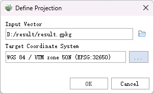
Define Projection
Function Description: Overwrites the coordinate system information (map projection and datum) stored with the vector data.
Data Description
- All geographic data have a coordinate system used for displaying, measuring, and converting geographic data. If the coordinate system of a dataset is unknown or incorrect, you can use this tool to specify the correct coordinate system.
- This tool only updates the existing coordinate system information; it does not modify any geometry. To convert geometry to another coordinate system, use the Projection tool.
Note: When defining the projection for .gpkg format geographic database data in LiDAR360MLS, the projection for all vector features within the database will be overwritten simultaneously.
Steps
- Locate the Batch Projection tool under Define Projection in the toolbox and double-click to open the function window.

Define Projection
Parameter Description:
- Input Vector: The feature class for which the projection will be defined.
- Target Coordinate System: The coordinate system to be applied to the input.