Field Calculator
Interface Layout and Corresponding Operations
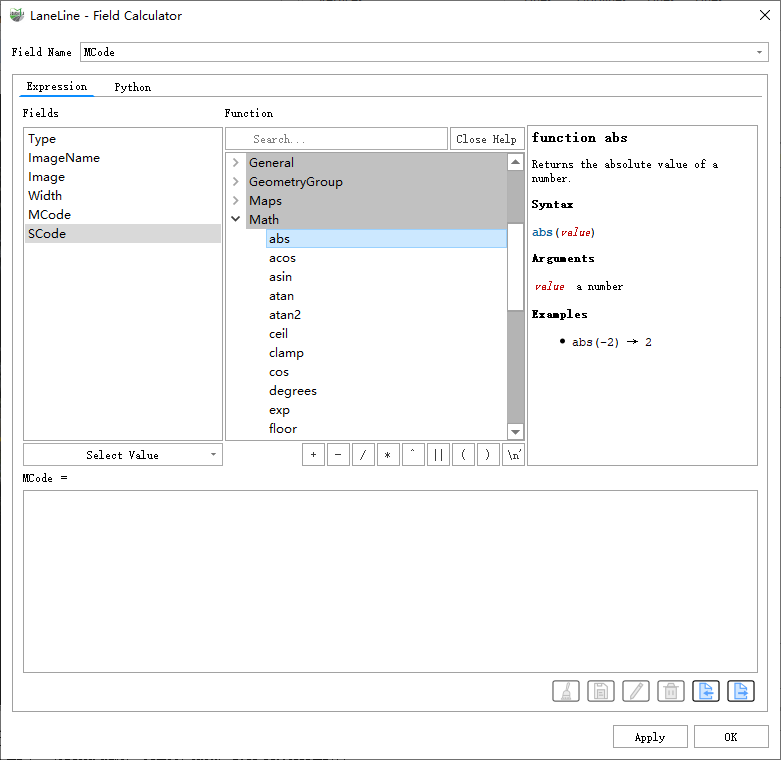
As shown in the figure, the Field Calculator mainly consists of five parts: 1.Target Field Selection; 2.Expression Type Switching; 3.Field Preview; 4.Function Preview; 5.Expression Editing.
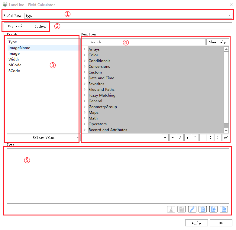
Target Field Selection
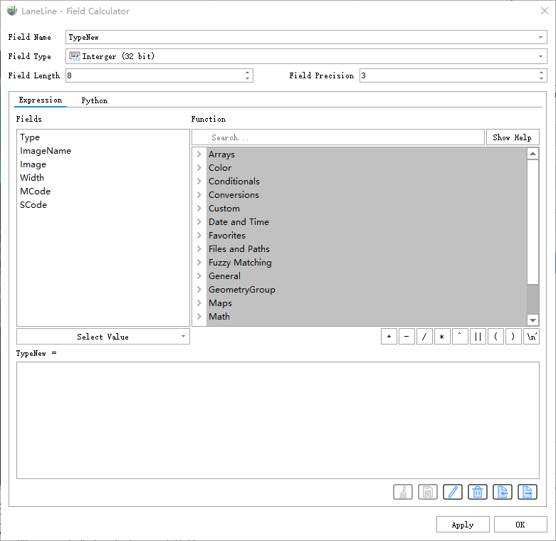
Click the dropdown box to select the field to be calculated. If you need to apply the expression to a new field, you can directly enter the name of the target field in the field dropdown box. If the current field does not exist after editing, a control will pop up to set the type of the new field, as shown:
Expression Type Switching
You can choose between the Expression Interface or Python Script Interface for editing. The default view is the Expression Interface. The Python Script Interface is shown below:
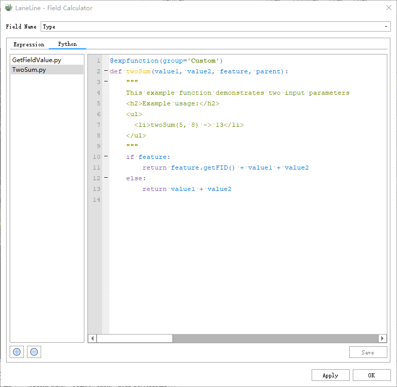
Use the new button in the lower-left corner to create a new Python script, and use the delete button to remove scripts. After editing the Python expression, click the save button to save the changes to the script.
Field Preview
The list displays all available fields in the current layer. Double-clicking a field will automatically add it to the function editing area. If the currently selected field has valid values in the attribute table, you can select a valid value from the value area below the list, which will be automatically added to the function editing area upon clicking.
Function Preview
The Field Calculator provides several built-in functions. You can enter the function name in the search box, and the required function will be automatically displayed. Click "Show Help" to view the function's usage instructions, methods, and examples. Similar to the Field Preview, double-clicking the function name will add it to the function editing area.
Expression Editing
Expression editing in the Field Calculator supports two calculation methods: using built-in functions and basic operators or custom Python scripts.
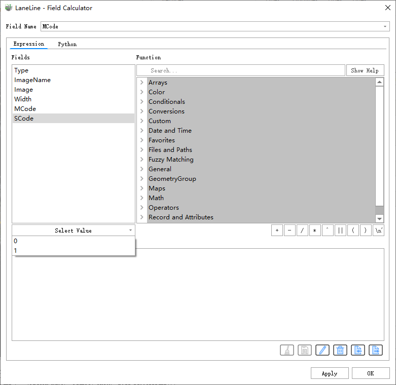
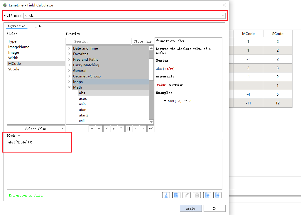
Example 1: Modify the Value of a Field
Change the value of field "SCode" to the absolute value of the field "MCode" plus 1. First, select the field "SCode" in the field name section. Then, in the function expression editing area below, write the expression. After completing the expression, if it is valid, click "Apply" to complete the modification after the calculation is done.
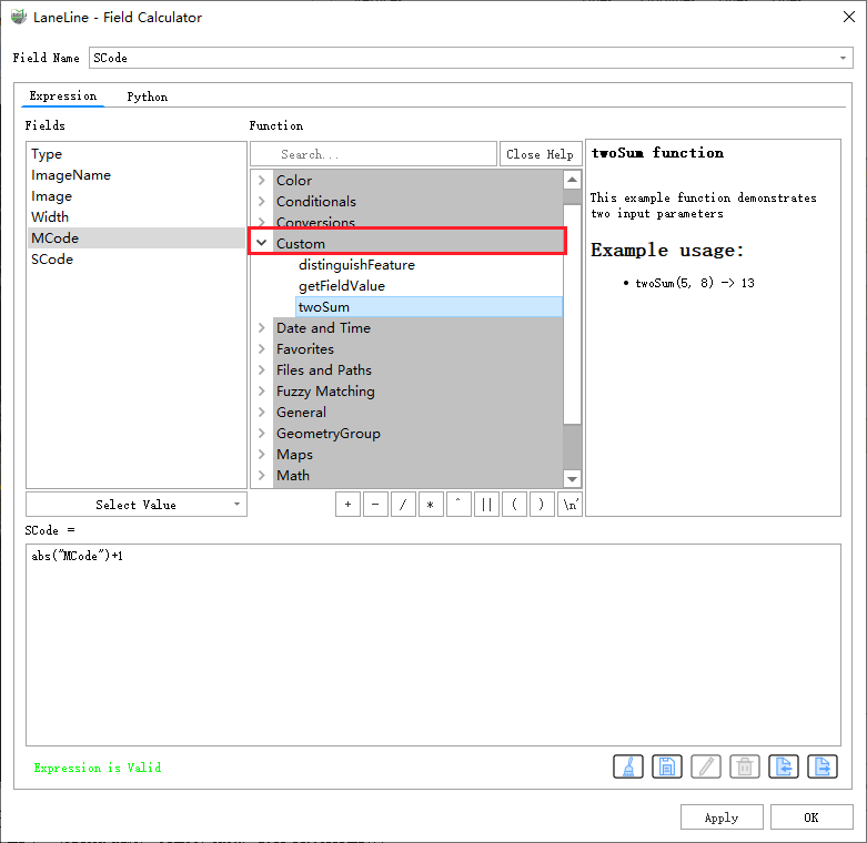
Example 2: Use Python Expressions for Calculation
1.Write a Python script: This script calculates the sum of two numbers. After completing it, click the save button in the lower-right corner to use it in the Expression Interface.
Note: In the first line of the script,
group='**Custom**', where Custom is the group name displayed in the function list.
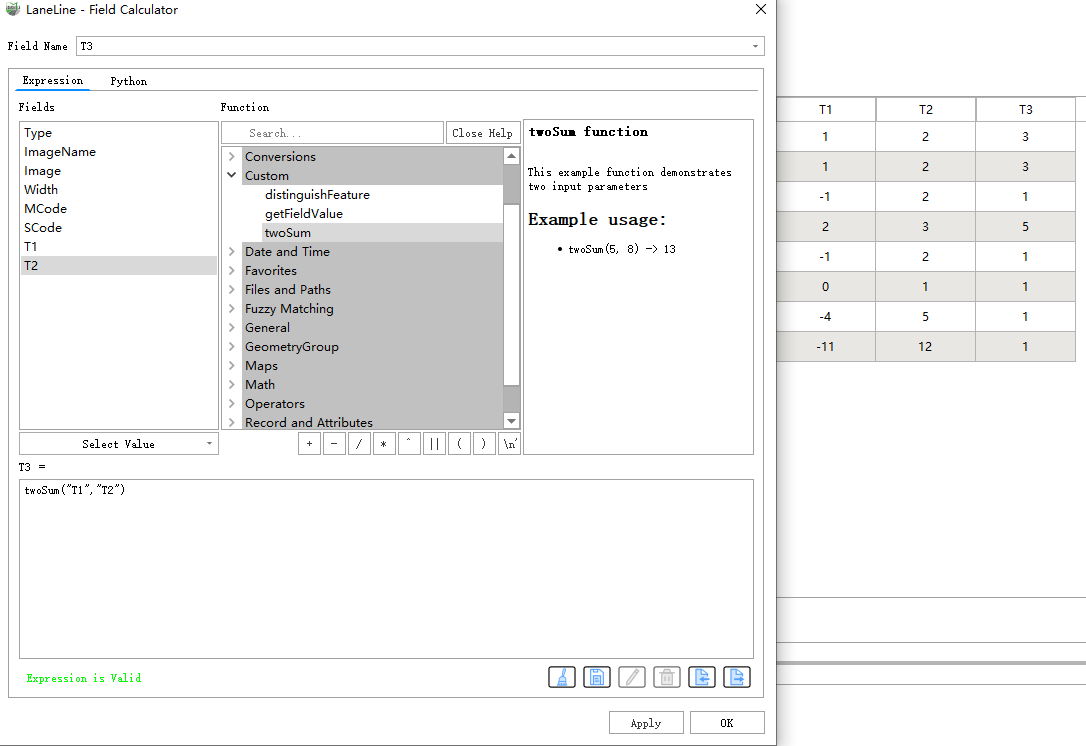
2.After editing, it can be used in the Expression Editing page. In this example, use the twoSum function created in Step 1 to add fields T1 and T2, and assign the result to the newly created field T3.
Reference Table
| name | Description |
|---|---|
| array_foreach | Returns an array with the given expression evaluated on each item. |
| array_filter | Returns an array with only the items for which the expression evaluates to true. |
| array | Returns an array containing all the values passed as parameter. |
| array_sort | Returns the provided array with its elements sorted. |
| array_length | Returns the number of elements of an array. |
| array_count | Counts the number of occurrences of a given value in an array. |
| array_majority | Returns the most common values in an array. |
| array_max | Returns the maximum value of an array. |
| array_mean | Returns the mean of arithmetic values in an array. Non numeric values in the array are ignored. |
| array_median | Returns the median of arithmetic values in an array. Non arithmetic values in the array are ignored. |
| array_min | Returns the minimum value of an array. |
| array_contains | Returns true if an array contains the given value. |
| array_minority | Returns the most no common values in an array. |
| array_prioritize | Returns an array sorted using the ordering specified in another array. Values which are present in the first array but are missing from the second array will be added to the end of the result. |
| array_replace | Returns an array with the supplied value, array, or map of values replaced. |
| array_sum | Returns the sum of arithmetic values in an array. Non numeric values in the array are ignored. |
| array_all | Returns true if an array contains all the values of a given array. |
| array_find | Returns the index (0 for the first one) of a value within an array. Returns -1 if the value is not found. |
| array_get | Returns the Nth value (0 for the first one) of an array. |
| array_first | Returns the first value of an array. |
| array_last | Returns the last value of an array. |
| array_append | Returns an array with the given value added at the end. |
| array_prepend | Returns an array with the given value added at the beginning. |
| array_insert | Returns an array with the given value added at the given position. |
| array_remove_at | Returns an array with the given index removed. |
| array_remove_all | Returns an array with all the entries of the given value removed. |
| array_cat | Returns an array containing all the given arrays concatenated. |
| array_slice | Returns a portion of the array. The slice is defined by the start_pos and end_pos arguments. |
| array_reverse | Returns the given array with array values in reversed order. |
| array_intersect | Returns true if at least one element of array1 exists in array2. |
| array_distinct | Returns an array containing distinct values of the given array. |
| array_to_string | Concatenates array elements into a string separated by a delimiter and using optional string for empty values. |
| string_to_array | Splits string into an array using supplied delimiter and optional string for empty values. |
| generate_series | Creates an array containing a sequence of numbers. |
| regexp_matches | Returns an array of all strings captured by capturing groups, in the order the groups themselves appear in the supplied regular expression against a string. |
| geometries_to_array | Splits a geometry into simpler geometries in an array. |
| color_rgb | Returns a string representation of a color based on its red, green, and blue components. |
| color_rgba | Returns a string representation of a color based on its red, green, blue, and alpha (transparency) components. |
| color_mix_rgb | Returns a string representing a color mixing the red, green, blue, and alpha values of two provided colors based on a given ratio. |
| color_grayscale_average | Applies a grayscale filter and returns a string representation from a provided color. |
| color_hsl | Returns a string representation of a color based on its hue, saturation, and lightness attributes. |
| color_hsla | Returns a string representation of a color based on its hue, saturation, lightness and alpha (transparency) attributes |
| color_hsv | Returns a string representation of a color based on its hue, saturation, and value attributes. |
| color_hsva | Returns a string representation of a color based on its hue, saturation, value and alpha (transparency) attributes. |
| color_cmyk | Returns a string representation of a color based on its cyan, magenta, yellow and black components |
| color_cmyka | Returns a string representation of a color based on its cyan, magenta, yellow, black and alpha (transparency) components |
| color_part | Returns a specific component from a color string, e.g., the red component or alpha component. |
| darker | Returns a darker (or lighter) color string |
| lighter | Returns a lighter (or darker) color string |
| set_color_part | Sets a specific color component for a color string, e.g., the red component or alpha component. |
| coalesce | Returns the first non-NULL value from the expression list. This function can take any number of arguments. |
| nullif | Returns a null value if value1 equals value2; otherwise it returns value1. This can be used to conditionally substitute values with NULL. |
| if | Tests a condition and returns a different result depending on the conditional check. |
| try | Tries an expression and returns its value if error-free. If the expression returns an error, an alternative value will be returned when provided otherwise the function will return null. |
| to_int | Converts a string to integer number. Nothing is returned if a value cannot be converted to integer (e.g '123asd' is invalid). |
| to_real | Converts a string to a real number. Nothing is returned if a value cannot be converted to real. Numbers are rounded after saving changes if the precision is smaller than the result of the conversion. |
| to_string | Converts a number to string. |
| to_datetime | Converts a string into a datetime object. An optional format string can be provided to parse the string. |
| to_date | Converts a string into a date object. An optional format string can be provided to parse the string. |
| to_time | Converts a string into a time object. An optional format string can be provided to parse the string. |
| to_interval | Converts a string to a interval type. Can be used to take days, hours, month, etc of a date. |
| to_dm | Convert a coordinate to degree, minute. |
| to_dms | Convert a coordinate to degree, minute, second. |
| to_decimal | Converts a degree, minute, second coordinate to its decimal equivalent. |
| now | Returns the current date and time. The function is static and will return consistent results while evaluating. The time returned is the time when the expression is prepared. |
| age | Returns the difference between two dates or datetimes. The difference is returned as a Interval and needs to be used with one of the following functions in order to extract useful information:
|
| year | Extracts the year part from a date, or the number of years from an interval. |
| month | Extracts the month part from a date, or the number of months from an interval. |
| week | Extracts the week number from a date, or the number of weeks from an interval. |
| day | Extracts the day from a date, or the number of days from an interval. |
| hour | Extracts the hour part from a datetime or time, or the number of hours from an interval. |
| minute | Extracts the minutes part from a datetime or time, or the number of minutes from an interval. |
| second | Extracts the seconds part from a datetime or time, or the number of seconds from an interval. |
| epoch | Returns the interval in milliseconds between the unix epoch and a given date value. |
| datetime_from_epoch | Returns a datetime whose date and time are the number of milliseconds. |
| day_of_week | Returns the day of the week for a specified date or datetime. The returned value ranges from 0 to 6, where 0 corresponds to a Sunday and 6 to a Saturday. |
| make_date | Creates a date value from year, month and day numbers. |
| make_time | Creates a time value from hour, minute and second numbers. |
| make_datetime | Creates a datetime value from year, month, day, hour, minute and second numbers. |
| make_interval | Creates an interval value from year, month, weeks, days, hours, minute and seconds values. |
| base_file_name | Returns the base name of the file without the directory or file suffix. |
| file_suffix | Returns the file suffix (extension) from a file path. |
| file_exists | Returns true if a file path exists. |
| file_name | Returns the name of a file (including the file extension), excluding the directory. |
| is_file | Returns true if a path corresponds to a file. |
| is_directory | Returns true if a path corresponds to a directory. |
| file_path | Returns the directory component of a file path. This does not include the file name. |
| file_size | Returns the size (in bytes) of a file. |
| levenshtein | Returns the Levenshtein edit distance between two strings. This equates to the minimum number of character edits (insertions, deletions or substitutions) required to change one string to another. The Levenshtein distance is a measure of the similarity between two strings. Smaller distances mean the strings are more similar, and larger distances indicate more different strings. The distance is case sensitive. |
| longest_common_substring | Returns the longest common substring between two strings. This substring is the longest string that is a substring of the two input strings. For example, the longest common substring of "ABABC" and "BABCA" is "ABC". The substring is case sensitive. |
| hamming_distance | Returns the Hamming distance between two strings. This equates to the number of characters at corresponding positions within the input strings where the characters are different. The input strings must be the same length, and the comparison is case-sensitive. |
| soundex | Returns the Soundex representation of a string. Soundex is a phonetic matching algorithm, so strings with similar sounds should be represented by the same Soundex code. |
| with_variable | This function sets a variable for any expression code that will be provided as 3rd argument. This is only useful for complicated expressions, where the same calculated value needs to be used in different places. |
| env | Gets an environment variable and returns its content as a string. If the variable is not found, NULL will be returned. This is handy to inject system specific configuration like drive letters or path prefixes. Definition of environment variables depends on the operating system, please check with your system administrator or the operating system documentation how this can be set. |
| var | Returns the value stored within a specified variable. |
| eval | Evaluates an expression which is passed in a string. Useful to expand dynamic parameters passed as context variables or fields. |
| $geometry | Returns the geometry of the current feature. Can be used for processing with other functions. |
| $area | Returns the area of the current feature. The area calculated by this function respects both the current project's ellipsoid setting and area unit settings. For example, if an ellipsoid has been set for the project then the calculated area will be ellipsoidal, and if no ellipsoid is set then the calculated area will be planimetric. |
| $length | Calculate the planar length of geometric line objects. |
| $perimeter | Returns the perimeter length of the current feature. The perimeter calculated by this function respects both the current project's ellipsoid setting and distance unit settings. For example, if an ellipsoid has been set for the project then the calculated perimeter will be ellipsoidal, and if no ellipsoid is set then the calculated perimeter will be planimetric. |
| $x | Returns the x-axis coordinate of a point feature. If the feature is a multi-point feature, the x-axis coordinate of the first point will be returned. |
| $y | Returns the y-axis coordinate of a point feature. If the feature is a multi-point feature, the y-axis coordinate of the first point will be returned. |
| $z | Returns the z-axis coordinate of a point feature. If the feature is a multi-point feature, the z-axis coordinate of the first point will be returned. |
| $m | Return the elevation value of the current point feature. |
| $x_at | Retrieves a x coordinate of the current feature's geometry. |
| $y_at | Retrieves a y coordinate of the current feature's geometry. |
| azimuth_angle | An attribute that stores the start-end bearing of each line feature segment will be added. Values range from 0 to 360, where 0 is north, 90 is east, 180 is south, 270 is west, and so on. |
| number_of_curves | Obtain the attribute of the number of curves in each element |
| z_ac | Retrieves a z coordinate of the geometry, or NULL if the geometry has no z value. |
| x_ac | Retrieves a x coordinate of the geometry. |
| y_ac | Retrieves a y coordinate of the geometry. |
| m_ac | Retrieves a m coordinate of the geometry, or NULL if the geometry has no m value. |
| move_geometry | Moving geometry. |
| area | Returns the area of a geometry polygon object. Calculations are always planimetric in the Spatial Reference System (SRS) of this geometry, and the units of the returned area will match the units for the SRS. This differs from the calculations performed by the $area function, which will perform ellipsoidal calculations based on the project's ellipsoid and area unit settings. |
| perimeter | Returns the perimeter of a geometry polygon object. Calculations are always planimetric in the Spatial Reference System (SRS) of this geometry, and the units of the returned perimeter will match the units for the SRS. This differs from the calculations performed by the $perimeter function, which will perform ellipsoidal calculations based on the project's ellipsoid and distance unit settings. |
| is_valid | Returns true if a geometry is valid; if it is well-formed in 2D according to the OGC rules. |
| x | Returns the x coordinate of a point geometry, or the x-coordinate of the centroid for a non-point geometry. |
| y | Returns the y coordinate of a point geometry, or the y-coordinate of the centroid for a non-point geometry. |
| z | Returns the z coordinate of a point geometry. |
| m | Returns the m value of a point geometry. |
| point_n | Returns a specific node from a geometry. |
| start_point | Returns the first node from a geometry. |
| end_point | Returns the last node from a geometry. |
| segments_to_lines | Returns a multi line geometry consisting of a line for every segment in the input geometry. |
| make_point | Creates a point geometry from an x and y (and optional z and m) value. |
| make_line | Creates a line geometry from a series of point geometries. |
| make_polygon | Creates a polygon geometry from an outer ring and optional series of inner ring geometries. |
| make_triangle | Creates a triangle polygon. |
| make_circle | Creates a circular polygon. |
| make_ellipse | Creates an elliptical polygon. |
| make_regular_polygon | Creates a regular polygon. |
| make_square | Creates a square from a diagonal. |
| make_rectangle_3points | Creates a rectangle from 3 points. |
| x_min | Returns the minimum x coordinate of a geometry. Calculations are in the spatial reference system of this geometry. |
| x_max | Returns the maximum x coordinate of a geometry. Calculations are in the spatial reference system of this geometry. |
| y_min | Returns the minimum y coordinate of a geometry. Calculations are in the spatial reference system of this geometry. |
| y_max | Returns the maximum y coordinate of a geometry. Calculations are in the spatial reference system of this geometry. |
| geom_from_wkt | Returns a geometry created from a Well-Known Text (WKT) representation. |
| geom_from_wkb | Returns a geometry created from a Well-Known Binary (WKB) representation. |
| flip_coordinates | Returns a copy of the geometry with the x and y coordinates swapped. Useful for repairing geometries which have had their latitude and longitude values reversed. |
| intersects_bbox | Tests whether a geometry's bounding box overlaps another geometry's bounding box. Returns true if the geometries spatially intersect the bounding box defined and false if they do not. |
| disjoint | Tests whether geometries do not spatially intersect. Returns true if the geometries do not share any space together. |
| intersects | Tests whether a geometry intersects another. Returns true if the geometries spatially intersect (share any portion of space) and false if they do not. |
| touches | Tests whether a geometry touches another. Returns true if the geometries have at least one point in common, but their interiors do not intersect. |
| crosses | Tests whether a geometry crosses another. Returns true if the supplied geometries have some, but not all, interior points in common. |
| contains | Tests whether a geometry contains another. Returns true if and only if no points of geometry b lie in the exterior of geometry a, and at least one point of the interior of b lies in the interior of a. |
| overlaps | Tests whether a geometry overlaps another. Returns true if the geometries share space, are of the same dimension, but are not completely contained by each other. |
| within | Tests whether a geometry is within another. Returns true if the geometry a is completely within geometry b. |
| buffer | Returns a geometry that represents all points whose distance from this geometry is less than or equal to distance. Calculations are in the Spatial Reference System of this geometry. |
| single_sided_buffer | Returns a geometry formed by buffering out just one side of a linestring geometry. Distances are in the Spatial Reference System of this geometry. |
| extend | Extends the start and end of a linestring geometry by a specified amount. Lines are extended using the bearing of the first and last segment in the line. Distances are in the Spatial Reference System of this geometry. |
| centroid | Returns the geometric center of a geometry. |
| point_on_surface | Returns a point guaranteed to lie on the surface of a geometry. |
| reverse | Reverses the direction of a line string by reversing the order of its vertices. |
| exterior_ring | Returns a line string representing the exterior ring of a polygon geometry. If the geometry is not a polygon then the result will be null. |
| interior_ring_n | Returns a specific interior ring from a polygon geometry, or null if the geometry is not a polygon. |
| geometry_n | Returns a specific geometry from a geometry collection, or null if the input geometry is not a collection. |
| boundary | Returns the closure of the combinatorial boundary of the geometry (ie the topological boundary of the geometry). For instance, a polygon geometry will have a boundary consisting of the linestrings for each ring in the polygon. Some geometry types do not have a defined boundary, e.g., points or geometry collections, and will return null. |
| bounds | Returns a geometry which represents the bounding box of an input geometry. Calculations are in the Spatial Reference System of this geometry. |
| simplify | Simplifies a geometry by removing nodes using a distance based threshold (ie, the Douglas Peucker algorithm). The algorithm preserves large deviations in geometries and reduces the number of vertices in nearly straight segments. |
| smooth | Smooths a geometry by adding extra nodes which round off corners in the geometry. If input geometries contain Z or M values, these will also be smoothed and the output geometry will retain the same dimensionality as the input geometry. |
| project | Returns a point projected from a start point using a distance, a bearing (azimuth) and an elevation in radians. |
| num_points | Returns the number of vertices in a geometry. |
| num_interior_rings | Returns the number of interior rings in a polygon or geometry collection, or null if the input geometry is not a polygon or collection. |
| num_rings | Returns the number of rings (including exterior rings) in a polygon or geometry collection, or null if the input geometry is not a polygon or collection. |
| num_geometries | Returns the number of geometries in a geometry collection, or null if the input geometry is not a collection. |
| bounds_width | Returns the width of the bounding box of a geometry. Calculations are in the Spatial Reference System of this geometry. |
| bounds_height | Returns the height of the bounding box of a geometry. Calculations are in the Spatial Reference System of this geometry. |
| is_closed | Returns true if a line string is closed (start and end points are coincident), or false if a line string is not closed. If the geometry is not a line string then the result will be null. |
| close_line | Returns a closed line string of the input line string by appending the first point to the end of the line, if it is not already closed. If the geometry is not a line string or multi line string then the result will be null. |
| is_empty | Returns true if a geometry is empty (without coordinates), false if the geometry is not empty and NULL if there is no geometry. See also is_empty_or_null. |
| is_empty_or_null | Returns true if a geometry is NULL or empty (without coordinates) or false otherwise. This function is like the expression '$geometry IS NULL or is_empty($geometry)' |
| convex_hull | Returns the convex hull of a geometry. It represents the minimum convex geometry that encloses all geometries within the set. |
| oriented_bbox | Returns a geometry which represents the minimal oriented bounding box of an input geometry. |
| minimal_circle | Returns the minimal enclosing circle of a geometry. It represents the minimum circle that encloses all geometries within the set. |
| difference | Returns a geometry that represents that part of geometry_a that does not intersect with geometry_b. |
| distance | Returns the minimum distance (based on spatial ref) between two geometries in projected units. |
| intersection | Returns a geometry that represents the shared portion of two geometries. |
| sym_difference | Returns a geometry that represents the portions of two geometries that do not intersect. |
| combine | Returns the combination of two geometries. |
| union | Returns a geometry that represents the point set union of the geometries. |
| geom_to_wkt | Returns the Well-Known Text (WKT) representation of the geometry without SRID metadata. |
| geom_to_wkb | Returns the Well-Known Binary (WKB) representation of a geometry |
| geometry | Returns a feature's geometry. |
| is_multipart | Returns true if the geometry is of Multi type. |
| z_max | Returns the maximum z coordinate of a geometry. |
| z_min | Returns the minimum z coordinate of a geometry. |
| m_max | Returns the maximum m (measure) value of a geometry. |
| m_min | Returns the minimum m (measure) value of a geometry. |
| closest_point | Returns the point on geometry1 that is closest to geometry2. |
| shortest_line | Returns the shortest line joining geometry1 to geometry2. The resultant line will start at geometry1 and end at geometry2. |
| line_interpolate_point | Returns the point interpolated by a specified distance along a linestring geometry. |
| angle_at_vertex | Returns the bisector angle (average angle) to the geometry for a specified vertex on a linestring geometry. Angles are in degrees clockwise from north. |
| distance_to_vertex | Returns the distance along the geometry to a specified vertex. |
| line_substring | Returns the portion of a line (or curve) geometry which falls between the specified start and end distances (measured from the beginning of the line). Z and M values are linearly interpolated from existing values. |
| ellipseArea | Returns the area of a geometry polygon object. Calculations are always planimetric in the Spatial Reference System (SRS) of this geometry, and the units of the returned area will match the units for the SRS. This differs from the calculations performed by the $area function, which will perform ellipsoidal calculations based on the project's ellipsoid and area unit settings. |
| geometrylength | Calculate the planar length of geometric line objects. |
| straight_distance_2d | Returns the direct/euclidean distance between the first and last vertex of a geometry. The geometry must be a curve (circularstring, linestring). |
| sinuosity | Returns the sinuosity of a curve, which is the ratio of the curve length to the straight (2D) distance between its endpoints. |
| relate | Tests the Dimensional Extended 9 Intersection Model (DE-9IM) representation of the relationship between two geometries. |
| pole_of_inaccessibility | Calculates the approximate pole of inaccessibility for a surface, which is the most distant internal point from the boundary of the surface. This function uses the 'polylabel' algorithm (Vladimir Agafonkin, 2016), which is an iterative approach guaranteed to find the true pole of inaccessibility within a specified tolerance. More precise tolerances require more iterations and will take longer to calculate. |
| offset_curve | Returns a geometry formed by offsetting a linestring geometry to the side. Distances are in the Spatial Reference System of this geometry. |
| hausdorff_distance | Returns the Hausdorff distance between two geometries. This is basically a measure of how similar or dissimilar 2 geometries are, with a lower distance indicating more similar geometries. The function can be executed with an optional densify fraction argument. If not specified, an approximation to the standard Hausdorff distance is used. This approximation is exact or close enough for a large subset of useful cases. Examples of these are: If the default approximate provided by this method is insufficient, specify the optional densify fraction argument. Specifying this argument performs a segment densification before computing the discrete Hausdorff distance. The parameter sets the fraction by which to densify each segment. Each segment will be split into a number of equal-length subsegments, whose fraction of the total length is closest to the given fraction. Decreasing the densify fraction parameter will make the distance returned approach the true Hausdorff distance for the geometries. |
| line_merge | Returns a LineString or MultiLineString geometry, where any connected LineStrings from the input geometry have been merged into a single linestring. This function will return null if passed a geometry which is not a LineString/MultiLineString. |
| make_valid | Returns a valid geometry or an empty geometry if the geometry could not be made valid. |
| make_point_m | Creates a point geometry from an x, y coordinate and m value. |
| roundness | Calculates how close a polygon shape is to a circle. The function Returns TRUE when the polygon shape is a perfect circle and 0 when it is completely flat. |
| geometry_type | Returns a string value describing the type of a geometry (Point, Line or Polygon) |
| shared_paths | Returns a collection containing paths shared by the two input geometries. Those going in the same direction are in the first element of the collection, those going in the opposite direction are in the second element. The paths themselves are given in the direction of the first geometry. |
| line_locate_point | Returns the distance along a linestring corresponding to the closest position the linestring comes to a specified point geometry. |
| inclination | Returns the inclination measured from the zenith (0) to the nadir (180) on point_a to point_b. |
| azimuth | Returns the north-based azimuth as the angle in radians measured clockwise from the vertical on point_a to point_b. |
| densify_by_count | Takes a polygon or line layer geometry and generates a new one in which the geometries have a larger number of vertices than the original one. |
| densify_by_distance | Takes a polygon or line layer geometry and generates a new one in which the geometries are densified by adding additional vertices on edges that have a maximum distance of the specified interval distance. |
| affine_transform | Returns the geometry after an affine transformation. Calculations are in the Spatial Reference System of this geometry. The operations are performed in a scale, rotation, translation order. If there is a Z or M offset but the coordinate is not present in the geometry, it will be added. |
| wedge_buffer | Returns a wedge shaped buffer originating from a point geometry. |
| wave_randomized | Constructs randomized curved (sine-like) waves along the boundary of a geometry. |
| wave | Constructs rounded (sine-like) waves along the boundary of a geometry. |
| triangular_wave_randomized | Constructs randomized triangular waves along the boundary of a geometry. |
| triangular_wave | Constructs triangular waves along the boundary of a geometry. |
| translate | Returns a translated version of a geometry. Calculations are in the Spatial Reference System of this geometry. |
| transform | Returns the geometry transformed from a source CRS to a destination CRS. |
| tapered_buffer | Creates a buffer along a line geometry where the buffer diameter varies evenly over the length of the line. |
| square_wave_randomized | Constructs randomized square/rectangular waves along the boundary of a geometry. |
| square_wave | Constructs square/rectangular waves along the boundary of a geometry. |
| simplify_vw | Simplifies a geometry by removing nodes using an area based threshold (ie, the Visvalingam-Whyatt algorithm). The algorithm removes vertices which create small areas in geometries, e.g., narrow spikes or nearly straight segments. |
| collect_geometries | Collects a set of geometries into a multi-part geometry object. |
| scale | Returns a scaled version of a geometry. Calculations are in the Spatial Reference System of this geometry. |
| rotate | Returns a rotated version of a geometry. Calculations are in the Spatial Reference System of this geometry. |
| order_parts | Orders the parts of a MultiGeometry by a given criteria |
| main_angle | Returns the angle of the long axis (clockwise, in degrees from North) of the oriented minimal bounding rectangle, which completely covers the geometry. |
| extrude | Returns an extruded version of the input (Multi-)Curve or (Multi-)Linestring geometry with an extension specified by x and y. |
| concave_hull | Returns a possibly concave polygon that contains all the points in the geometry. |
| buffer_by_m | Creates a buffer along a line geometry where the buffer diameter varies according to the m-values at the line vertices. |
| apply_dash_pattern | Applies a dash pattern to a geometry, returning a MultiLineString geometry which is the input geometry stroked along each line/ring with the specified pattern. |
| line_interpolate_angle | Returns the angle parallel to the geometry at a specified distance along a linestring geometry. Angles are in degrees clockwise from north. |
| nodes_to_points | Returns a multipoint geometry consisting of every node in the input geometry. |
| force_rhr | Forces a geometry to respect the Right-Hand-Rule, in which the area that is bounded by a polygon is to the right of the boundary. In particular, the exterior ring is oriented in a clockwise direction and the interior rings in a counter-clockwise direction. |
| force_polygon_cw | Forces a geometry to respect the convention where exterior rings are clockwise, interior rings are counter-clockwise. |
| force_polygon_ccw | Forces a geometry to respect the convention where exterior rings are counter-clockwise, interior rings are clockwise. |
| short_edge_length | Obtain the length of the shortest geometric edge. |
| long_edge_length | Obtain the length of the longest geometric edge. |
| $length3d | Calculate the three-dimensional length of line or polygon geometry. |
| $length_z | Calculate the length in the Z direction of line or polygon geometry. |
| geometrylength_3d | Calculate the three-dimensional length of line or polygon geometry. |
| geometrylength_z | Calculate the length in the Z direction of line or polygon geometry. |
| json_to_map | Creates a map from a json-formatted string. |
| from_json | Loads a JSON formatted string. |
| map_to_json | Merge map elements into a json-formatted string. |
| to_json | Create a JSON formatted string from a map, array or other value. |
| hstore_to_map | Creates a map from a hstore-formatted string. |
| map_to_hstore | Merge map elements into a hstore-formatted string. |
| map | Returns a map containing all the keys and values passed as pair of parameters. |
| map_get | Returns the value of a map, given it's key. |
| map_exist | Returns true if the given key exists in the map. |
| map_delete | Returns a map with the given key and its corresponding value deleted. |
| map_insert | Returns a map with an added key/value. |
| map_concat | Returns a map containing all the entries of the given maps. If two maps contain the same key, the value of the second map is taken. |
| map_akeys | Returns all the keys of a map as an array. |
| map_avals | Returns all the values of a map as an array. |
| map_prefix_keys | Returns a map with all keys prefixed by a given string. |
| sqrt | Returns square root of a value. |
| radians | Converts from degrees to radians. |
| degrees | Converts from radians to degrees. |
| abs | Returns the absolute value of a number. |
| cos | Returns cosine of an angle. |
| sin | Returns the sine of an angle. |
| tan | Returns the tangent of an angle. |
| asin | Returns the inverse sine of a value in radians. |
| acos | Returns the inverse cosine of a value in radians. |
| atan | Returns the inverse tangent of a value in radians. |
| atan2 | Returns the inverse tangent of dy/dx by using the signs of the two arguments to determine the quadrant of the result. |
| exp | Returns exponential of an value. |
| ln | Returns the natural logarithm of a value. |
| log10 | Returns the value of the base 10 logarithm of the passed expression. |
| log | Returns the value of the logarithm of the passed value and base. |
| round | Rounds a number to number of decimal places. |
| rand | Returns a random integer within the range specified by the minimum and maximum argument (inclusive). If a seed is provided, the returned will always be the same, depending on the seed. |
| randf | Returns a random float within the range specified by the minimum and maximum argument (inclusive). If a seed is provided, the returned will always be the same, depending on the seed. |
| max | Returns the largest value in a set of values. |
| min | Returns the smallest value in a set of values. |
| clamp | Restricts an input value to a specified range. |
| scale_linear | Transforms a given value from an input domain to an output range using linear interpolation. |
| scale_exp | Transforms a given value from an input domain to an output range using an exponential curve. This function can be used to ease values in or out of the specified output range. |
| scale_polynomial | Transforms a given value from an input domain to an output range using a polynomial curve. This function can be used to ease values in or out of the specified output range. |
| floor | Rounds a number downwards. |
| ceil | Rounds a number upwards. |
| pi | Returns value of pi for calculations. |
| $id | Returns the feature id of the current row. |
| $currentfeature | Returns the current feature being evaluated. This can be used with the 'attribute' function to evaluate attribute values from the current feature. |
| uuid | Generate a universally unique identifier (UUID) for each row. |
| feature_id | Returns a feature's unique ID, or NULL if the feature is not valid. |
| autoFill | Automatically accumulate the given field based on the input starting value and step size. |
| accumulation | Calculate the cumulative value of data. |
| attribute | Returns an attribute from a feature. |
| lower | Converts a string to lower case letters. |
| textInsert | Insert specified characters between strings. |
| textCenter | Center string text with padding on both sides. |
| upper | Converts a string to upper case letters. |
| title | Converts all words of a string to title case (all words lower case with leading capital letter). |
| trim | Removes all leading and trailing whitespace (spaces, tabs, etc) from a string. |
| char | Returns the character associated with a unicode code. |
| ascii | Returns the unicode code associated with the first character of a string. |
| wordwrap | Returns a string wrapped to a maximum/minimum number of characters. |
| length | Returns the number of characters in a string or the length of a geometry linestring. |
| replace | Returns a string with the supplied string, array, or map of strings replaced. |
| regexp_replace | Returns a string with the supplied regular expression replaced. |
| regexp_substr | Returns the portion of a string which matches a supplied regular expression. |
| substr | Returns a part of a string. |
| concat | Concatenates several strings to one. NULL values are converted to empty strings. Other values (like numbers) are converted to strings. |
| strpos | Return the first matching position of a substring within another string, or 0 if the substring is not found. |
| left | Returns a substring that contains the n leftmost characters of the string. |
| right | Returns a substring that contains the n rightmost characters of the string. |
| rpad | Returns a string padded on the right to the specified width, using a fill character. If the target width is smaller than the string's length, the string is truncated. |
| lpad | Returns a string padded on the left to the specified width, using a fill character. If the target width is smaller than the string's length, the string is truncated. |
| format | Format a string using supplied arguments. |
| format_number | Returns a number formatted with the locale separator for thousands. Also truncates the decimal places to the number of supplied places. |
| regexp_match | Return the first matching position matching a regular expression within a string, or 0 if the substring is not found. |
| format_date | Formats a date type or string into a custom string format. Uses Qt date/time format strings. |
| ltrim | Removes the longest string containing only the specified characters (a space by default) from the start of string. |
| rtrim | Removes the longest string containing only the specified characters (a space by default) from the end of string. |