Point to Raster
Function Description: Converts point features into a raster dataset.
How it works
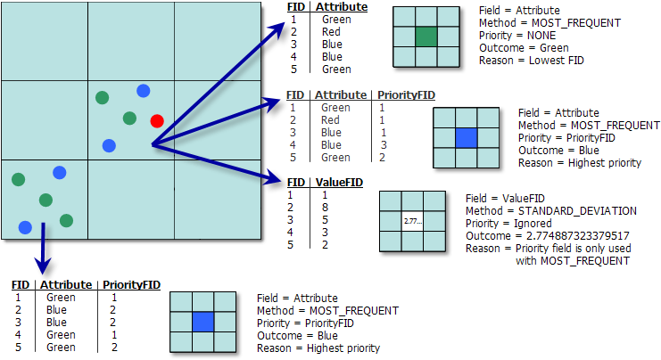
When using the Point to Raster tool to convert point feature classes to a raster, the pixel values are determined under various conditions as follows:
- If there is only one point in a pixel, the pixel value will be the value of that point.
- The priority field is only used with the Most frequent option.
- If there are multiple points in a pixel:
- If no priority is set or all priorities are the same, and
- The attributes are different, the value of the point with the smallest FID is used.
- Otherwise, the value of the point with the most common attribute is chosen. If still undetermined, the value of the point with the smallest FID is used.
- If priorities differ, and
- The attributes are different, the value of the point with the highest priority is chosen.
- If attributes are the same, the value of the point with the most common attribute is chosen. If needed, the point with the smallest FID is used.
- If no priority is set or all priorities are the same, and
Here are examples of different options for assigning values to pixels

Example: Multiple Points in the Same Pixel
Data Description
- Any feature class containing points or multipoint features can be converted into a raster dataset.
- The type of the input field determines the type of the output raster. If the field is integer, the output raster will also be integer; if the field is floating-point, the output raster will also be floating-point.
- If a pixel size is specified numerically, the tool will apply it directly to the output raster.
- This tool complements the Raster to Point tool, which converts rasters into point feature classes.
- When multiple features fall within the same output pixel, this tool offers more comprehensive control over pixel value assignment compared to the Feature to Raster tool.
- For data formats supporting Null values, such as file geodatabase feature classes, Null values will be ignored when used as input.
Steps
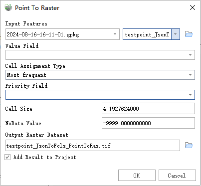
Find the Point to Raster tool in the toolbox and double-click to open the tool window.

Point to Raster
Parameter Description:
- Input Features: The point or multipoint feature dataset to be converted to a raster.
- Value Field: The field used to assign values to the output raster. This can be any field from the attribute table of the input feature dataset.
Cell Assignment Type (Optional): Determines how to assign values to cells when multiple features fall within a single cell.
- Most frequent—If multiple features are in a cell, the feature with the most common attribute in the Value Field is assigned to the cell. If there are multiple features with the same number of common attributes, the feature with the lowest FID is used.
- Sum—The sum of the attributes of all points in the cell (not applicable to string data).
- Mean—The average of the attributes of all points in the cell (not applicable to string data).
- Standard Deviation—The standard deviation of the attributes of all points in the cell. If fewer than two points are in the cell, NoData is assigned to the cell (not applicable to string data).
- Maximum—The maximum attribute value of all points in the cell (not applicable to string data).
- Minimum—The minimum attribute value of all points in the cell (not applicable to string data).
- Range—The range of attribute values of all points in the cell (not applicable to string data).
- Count—The number of points in the cell.
Priority Field: Used to determine if one feature should take precedence over others with the same attribute. This field is only used with the Most frequent cell assignment type option.
- Cell Size: The size of the cells in the output raster.
- NoData Value: The value used to specify the location of invalid areas in the raster.
- Output Raster Dataset: The raster dataset to be created.
- Add Result to Project: If checked, a layer for the result data will be automatically created and added to the project.