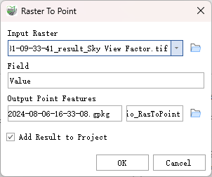
Raster to Point
Function Description: Converts a raster dataset into point features.
Data Description
For each pixel in the input raster dataset, a point will be created in the output feature class. These points will be located at the center of the pixels they represent. NoData pixels will not be converted to points.
The pixel size of the input raster can be arbitrary and can belong to any valid raster dataset.
The Field parameter allows you to specify which attribute field from the input raster dataset will become an attribute in the output feature class.
Steps
- Locate the Raster to Point tool under Raster Tools in the toolbox, and double-click to open the tool's window.

Raster to Point
Parameter Description:
- Input Raster: The input raster dataset, which can be either integer or floating-point data.
- Field: Specifies the field used to assign pixel values from the input raster to the points in the output feature class.
- Output Point Features: The output feature class that contains the converted points.
- Add Result to Project: This option is only applicable when the output feature class is saved to the same geodatabase as the project. When checked, it will automatically create a layer for the result data and add it to the project.