Feature Vertices To Points
Function Description: Creates a feature class containing points generated from specified vertices or locations of the input features.
Data Description
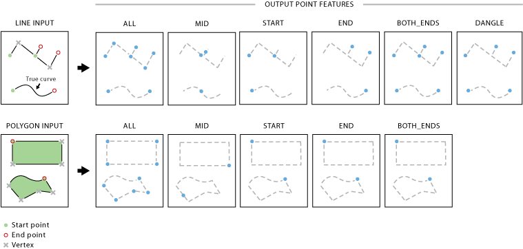
Input and Output Relationships

Input and Output Relationships for Feature Vertices To Points
Explanation:
- The attributes of the input features will be retained in the output feature class. A new field, ORIG_FID, will be added to the output feature class and set to the ID of the input feature.
- For multipart lines and polygons, each part is treated as a separate line. Thus, each part has its own start, end, and midpoint, as well as any dangling points.
- For the Dangle option in the Point Type parameter, an additional field, DANGLE_LEN, will be added to the output feature class to retain the length of dangling points in feature units. Both endpoints of an isolated line are considered dangling points, so the dangling length is the length of the line itself. For dangling lines where one endpoint intersects other lines, the dangling length is measured from the dangling endpoint to the intersection point.
Steps
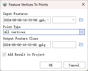
Find the Feature Vertices to Points tool in the toolbox and double-click to open the tool window.

Feature Vertices To Points
Parameter Description:
- Input Features: ASCII files or folders containing data in XYZ, XYZI (with LiDAR intensity), or 3D GENERATE format. All input files must be in the same format. If a folder is specified, the File Suffix parameter becomes mandatory and will process all files with the specified suffix and extension.
Point Type: Specifies where the output points will be created.
- All Vertices—Creates a point at every vertex of the input features. This is the default setting.
- Midpoints—Creates a point at the midpoint of each input line or polygon boundary (not necessarily a vertex).
- Starting Vertex—Creates a point at the start (first vertex) of each input feature.
- Ending Vertex—Creates a point at the end (last vertex) of each input feature.
- Starting and Ending Vertices—Creates a point at both the start and end of each input feature, resulting in two points per feature.
- Dangling Vertices—Creates a dangling point at the start or end of a line if the point does not connect to any part of another line. This option does not apply to polygon inputs.
Output Feature Class: The resulting feature class to be created.
Add Result to Project: This option is only effective if the output feature class is saved to a geopackage database within the project. Checking this option will automatically build a layer for the result data and add it to the project.