Framework FAQ
1.Is LiDAR360MLS software only able to handle vehicle-mounted laser point cloud data?
- No, LiDAR360MLS software supports all manufacturers of terrestrial laser scanning equipment on the market to enter the point cloud, trajectory, image data into the software for intelligent extraction and analysis of processing, such as LiGrip, LiBackpack, LiMobile, and other equipment to collect the data.
2.What data formats does LiDAR360MLS support?
- The data types that can be imported into LiDAR360MLS are divided into four categories: point cloud, trajectory, image and vector. The specific formats are as follows:
- Point cloud: LiData file (.LiData custom point cloud format), LAS file (.las, .laz), PLY file (.ply), E57 file (.e57).
- Trajectory: Trajectory data (.traj, .pos, .txt, .csv, .asc, .xyz, .pts, .out).
- Image: The image data is divided into panoramic camera and plane camera. It is necessary to ensure that the image recording file [Image List File(.imglist), Leica Pegasus File(.csv), Trimble MX9 File(.csv), Riegl MMS File(.csv), LIDARUSA SNOOPY File(.txt), OrbitPos(.txt, .csv)] and the image file storage location is accurate.
- Vector: vector data (Shape Files(.shp), Geojson Files(.geojson), Kml File(.kml), Dxf File(.dxf).
- The data formats that LiDAR360MLS can export are as follows:
- Point cloud: LiData file (.LiData custom point cloud format), LAS file (.las, .laz), ASCII file (.txt), PLY file (.ply), E57 file (.e57).
- Vector: Vector data (Shape Files(.shp), Geojson Files(.geojson), Kml File(.kml), Dxf File(.dxf).
- Model: Model data (.obj, .osgb).
3.After running the software, some of the displays were found to be in the wrong place, such as the misplaced hints in the 3D window of the element extraction function?
This usually happens when there are multiple graphics cards on the computer and the monitor is plugged into the integrated display.
You can first check if the monitor socket is plugged into a unique graphics card (NVIDIA is recommended), and it is recommended that the monitor is plugged into a unique graphics card.
If you do not want to change the position of the monitor socket, you can refer to Adjust High-Performance Graphics Mode to run the software in high performance mode.
4.The point cloud does not display in the new project software.
This situation usually occurs when there are more than one official NVIDIA panel, whose version is wrong. Or there is a software setting problem.
Download the corresponding version of NVIDIA Control Panel and refer to Adjustment of High-Performance Graphics Mode to run the software in high-performance mode. software to run in high-performance mode
5.How to view the help manual?
- Click File > Help, or just use the F1 shortcut to open the user manual.
6.How do I view the update instructions for LiDAR360MLS?
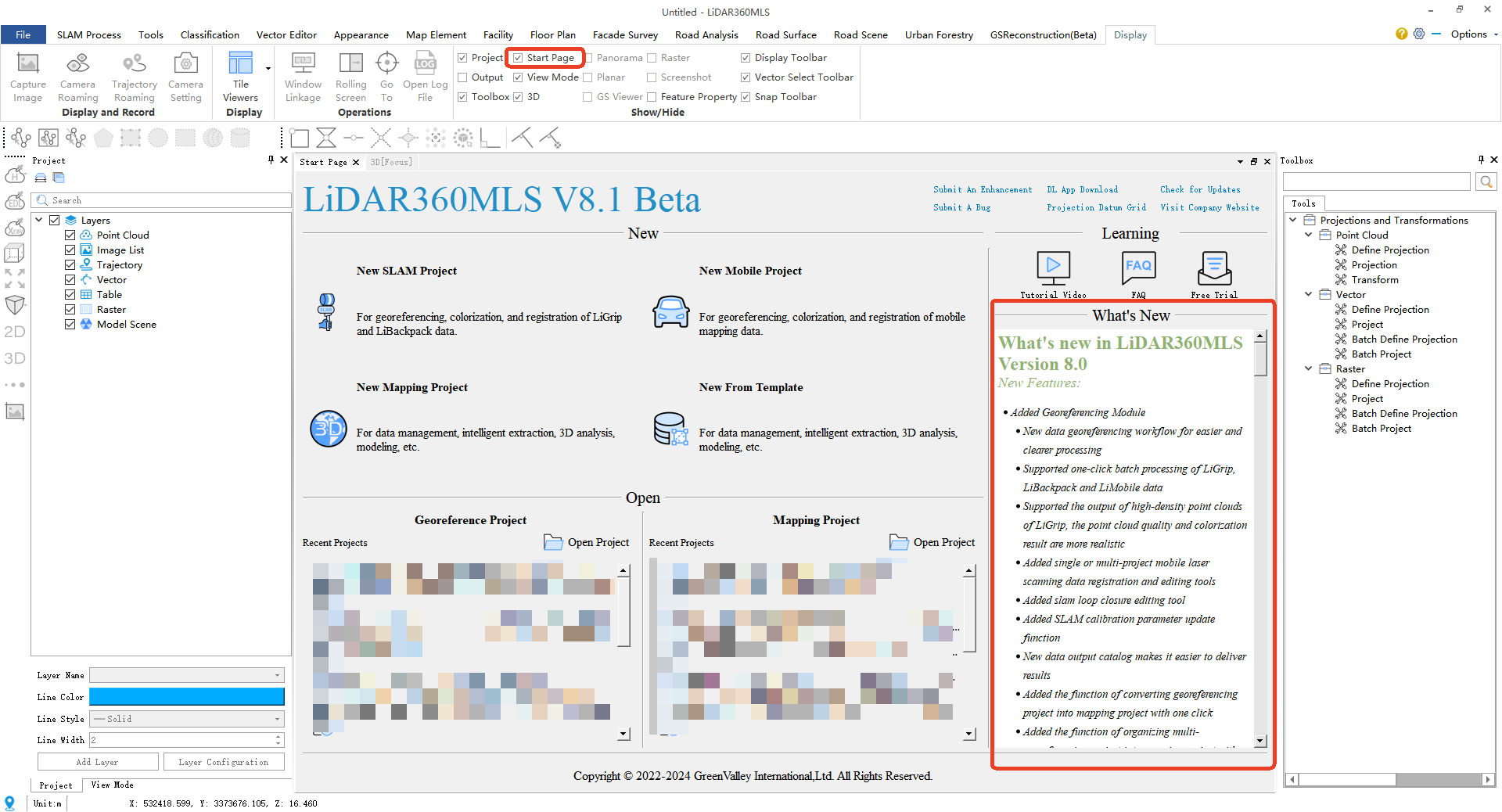
- The latest version of LiDAR360MLS is available on the startup page in the What's New section of the software.
- If the startup page is turned off, you can check the startup page option in the Show/Hide group of the display page.
7.How to check the version information of LiDAR360MLS software?
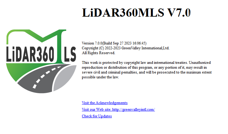
- Click File > About to view the version information of LiDAR360MLS software, as shown in the figure below, 7.0.0 is the software version number, and Sep 27 2023 16: 06: 45 is the compilation date.
8.How to change the language settings?
- Click File > Options > Language to switch between English, Chinese, Japanese and Traditional Chinese
9.Why does the software exit abnormally?
- When the software exits abnormally, please check: (1) Whether the on-screen word-taking software (such as Youdao Dictionary) is opened; (2) Whether there is enough hard disk space or memory space.
10.LiDAR360MLS software startup tips:"The current OpenGL version X.X is less than 4.5, which does not meet the software display requirements. Please check if the graphics adapter is connected properly or if the graphics driver is functioning correctly."
- Please check if the computer screen is plugged in correctly, normally it should be plugged into the host computer graphics card connector position.
- If the computer screen monitor is plugged in properly, please check and update the graphics card driver.
11.The high-resolution screen computer software cannot be started or the software is stuck?
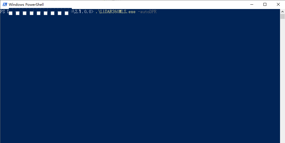
- Method 1: In the software installation directory (eg: D/LiDAR360MLS/2.1.0.0/), press and hold the Shift button of the keyboard, click the right mouse button, click "Open Power Shell window here", and enter the command line in the window .\LiDAR360MLS.exe -autoDPR, you can start the software normally on the high-resolution screen computer.
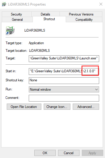
- Method 2: In the software installation directory (eg: D/LiDAR360MLS/2.1.0.0/), send the LiDAR360MLS.exe in the directory to the desktop shortcut, then right-click the shortcut, open the properties, and at the end of the target. Add -autoDPR, then double-click the program to start the software normally.
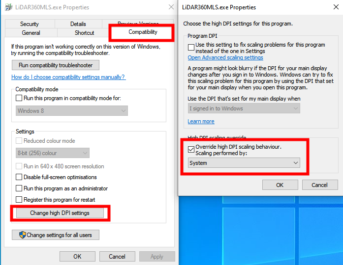
12.On a high-resolution screen, the software startup displays abnormally, with icons appearing unusually large.
- Right-click on the LiDAR360MLS startup program and click on "Properties."
- Switch to the "Compatibility" panel.
- Click on "Change high DPI settings."
- In the "High DPI scaling override" section, check the scaling behavior and modify it to "System."
- After applying the changes, launch the software, and the display should be normal.
13.After using the software for a long time, double-clicking to run it starts slowly?
Prepare the software activation code
In the ProgramData folder on the C drive, find the BitAnswer folder (C:\ProgramData\BitAnswer)
Note: The ProgramData folder is a hidden folder, you need to check the "Hidden Items" box in the view section of the folder to see the folder.
- Delete the contents of the BitAnswer folder and re-run the software to re-activate it to solve the problem of slow start-up.
14.After the software is launched, the interface displays garbled characters
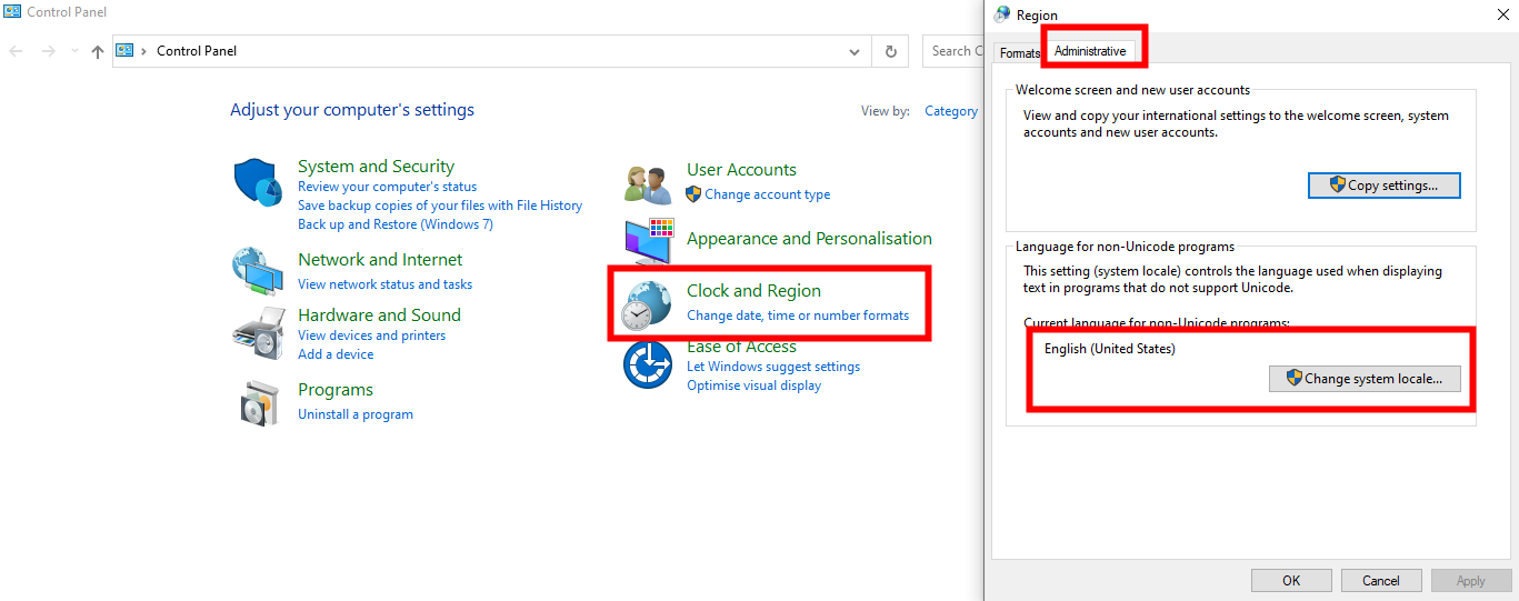
This issue commonly arises due to non-Unicode program language settings on the computer.
- Open the computer control panel.
- Locate the "Clock and Region" option.
- Click on "Change date, time, or number formats."
- Switch to the "Administrative" tab.
- In the "Language for non-Unicode programs," ensure that the language used by the current system is consistent with the setting here. For English Windows systems, the default setting is usually appropriate. If language packs for other languages, such as Chinese language packs, are installed, set this option to the corresponding language pack.
15.Recommended Process for Projective Transformation of Point Cloud Data
- In the pre-processing process, it is recommended to use the UTM coordinate system for processing, only when all the data are spliced and checked to be correct, then go to do the projection transformation to convert to the self-defined target coordinate system.
- And when doing mapping and analysis, directly based on the point cloud data that has been converted to projection processing, post-processing is not recommended to go back to the target conversion.
16.When running the Deep Learning classification function, the software prompts that nvml.dll cannot be found, what should I do?
- If your computer does not have NVIDIA graphics card, you can continue to use the deep learning classification function after this prompt, but you can only use the CPU mode.
- If your computer has NVIDIA graphics card, please make sure whether you have installed the graphics card driver correctly. If you still have this problem after installing or updating the graphics card driver, you can add C:\Program Files\NVIDIA Corporation\NVSMI (the path is determined by the user's graphics card driver installation directory) to the system environment variable Path. At this time, the classification function can continue to use the GPU mode normally.
17.The whole preprocessing page is gray and can't be used?
- Please check whether the track data is added in the project, the preprocessing page must have track data before it can be used normally.
18.The software prompts the lack of a dll file, how to deal with?
- The cause of this problem is usually antivirus software kill, LiDAR360MLS has been added to a number of commonly used antivirus software whitelist, but there may still be a phenomenon of misuse. If you encounter this problem, you can restore the wrongly killed files in the antivirus program to solve the problem.
19.When doing vector editing or point-and-click viewing, the vector always jumps to the global view instead of staying at the clicked position.
- This problem can be encountered in the file → Options → Linkage Settings → Vector Linkage Settings, set it to unchecked, can solve the problem of linkage
- If you have an image, you need to disable the image linkage setting at the same time.
20.When selecting vectors from the attribute table, the vectors in the 3D window cannot be associated with a jump to the currently selected vector object.
- This problem can be encountered in the File → Options → Linkage Settings → Vector Linkage Settings, set it as a check box, you can linkage!
- If there is an image, turn on the image linkage setting at the same time, you can synchronize the panorama/flat window linkage.
21.[Error]"The resolution ratio of ‘XXX/XXX.jpg’ is not 2:1".
- Reason:The software only supports standard panoramic photo, the aspect ratio is 2:1.
- Solution:When you encounter this problem, please check the resolution of the panoramic photos, such as ladybug, insta, and other panoramic cameras do not crop the photos
22.[Warning]"The minimum distance between the selected point and the exposure points is greater than 200, no skip will be performed."
- Reason:TThis problem is encountered because the images in the project at this time cannot correspond to vectors and point clouds, resulting in a failure to jump when selecting vector objects.
- Solution:Please check the image data used for the project for errors.
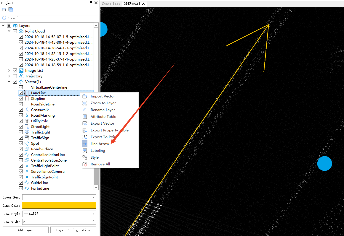
23.How do I view the direction of a line?
- In the directory tree, select the layer that needs to show the direction of the line, then right-click on the layer and select the line arrow option in the menu bar to turn on the line arrow
- To turn off the line arrows, do the same thing, and then re-click on the line arrows option.
24.If I accidentally close a 3D or other data window, where do I open it from?
- Check the corresponding window option in the Show/Hide group on the Display page to open it!

25.The software prompts "Unable to open this project as it was made with a newer version of the LiDAR360MLS" when opening a mapping project?
- This problem is due to the fact that when the software is upgraded, the project files are occasionally upgraded and optimized, so the version of the synchronized project files will be upgraded. The lower version of the software cannot open the project generated by the higher version of the software. You need to use the latest released version of the software to open the project.
26.If your computer experiences frequent crashes while running programs, please first check whether your CPU model is an Intel i9-13th/14th Gen.
- The i9-13th/14th Gen CPUs have inherent stability issues; please follow the official instructions to perform necessary updates.Intel Core 13th and 14th Gen Desktop Instability Root Cause Update
27.Software prompt:[Asset Extraction]This module is not authorized! Please contact info@greenvalleyintl.com to get a full version.
- This problem occurs because the authorization does not contain the abbreviated module in parentheses, if you have not purchased the need to use, please contact sales to purchase; if you have purchased the module is still prompted, please contact sales to confirm the authorization code module
28.What should I do if the software prompts "The software has encountered an unknown exception. please restart the software." when using the software?
- This message means that the software has encountered an unexpected error that could not be handled automatically. Such errors may be triggered by unstable plugins, corrupted or incompatible data files, or unexpected system environment issues. To troubleshoot:
- Restart the software and check if the problem happens again.
- If the error only occurs with a specific dataset or project, try another dataset/project to confirm.
- Ensure your operating system and graphics drivers are updated to the latest version.
- If the problem continues, please submit a bug report via the software: click Options → Submit A Bug in the top-right corner of the software, and provide the user operation log and any relevant context or workflow information that led to the issue for further analysis.
The problems and solutions related to each function of the platform module are described in detail: