Polyline to Raster
Function Description: Converts polyline features to a raster dataset.
How It Works
The following explains how to specify cell values under various conditions when using the Polyline to Raster tool.
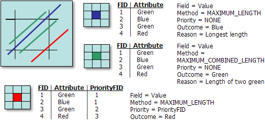
When multiple features fall into a single cell, there are two methods to control how the cell value is assigned. These methods are described as follows:
Maximum Length Method
- If there is only one line in the cell, that line is selected.
- If there are multiple lines in the cell, and:
- Priority is not set or priorities are the same, the line with the smallest FID is selected.
- Regardless of length, the line with the highest positive priority value is always selected for conversion.
Maximum Combined Length Method
When setting the Cell Assignment Type parameter to Maximum Combined Length:
- If there is only one line in the cell, that line is selected.
- If there are multiple lines in the cell, and:
- Priority is not set or priorities are the same, the line with the smallest FID is selected.
- Regardless of length, the line with the highest positive priority value is always selected for conversion.
Note: Combined features are treated as a single feature, with the FID taken from the smallest value among the combined features, and the priority taken from the highest value among the combined features.
Examples of using different options for cell value assignment methods

A diagram illustrating four polylines overlapping the same cell
Data Description
- Any feature class containing polyline features can be converted to a raster dataset.
- The type of input field determines the type of the output raster. If the field is integer, the output raster will also be integer; if the field is floating-point, the output raster will be floating-point.
- If a pixel size is specified numerically, the tool will use it directly for the output raster.
- This tool complements the Raster to Polyline tool, which converts a raster to a polyline feature class.
- When multiple features overlap a cell, this tool provides more comprehensive control over pixel value assignment compared to the Feature to Raster tool.
- For data formats that support Null values, such as file geodatabase feature classes, Null values will be ignored when used as input.
Steps
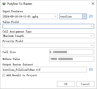
Find the Polyline to Raster tool under the toolbox, and double-click to open the tool window.

Polyline to Raster
Parameter Description:
- Input Features: The polyline feature dataset to be converted to a raster.
- Value Field: The field used to assign values to the output raster. It can be any numeric field from the attribute table of the input feature dataset.
Cell Assignment Type (Optional): Determines the method for assigning values to cells when multiple features fall within a cell.
- Maximum Length — The feature with the maximum length overlapping the cell determines the value assigned to the cell.
- Maximum Combined Length — If multiple features in the cell have the same value, their combined length is calculated. The feature with the maximum combined length determines the value assigned to the cell.
Priority Field: This field determines which feature should take precedence over others in the cell. When used, regardless of the Cell Assignment Type chosen, the feature with the highest positive priority value is selected for conversion.
- Cell Size: The cell size of the output raster being created.
- NoData Value: The value used to specify invalid areas in the raster.
- Output Raster Dataset: The raster dataset to be created.
- Add Result to Project: If checked, a layer for the result data will be automatically created and added to the project.