Data Copy
Operation Instructions
1.Click Data Copy button, pop up the Merge Data dialog box .
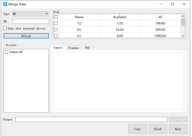
2.After selecting the disk, it will search for all projects in the "Data" folder of the selected disk, obtain the type of the first project to set the Type on the interface, or manually switch the Type.
3.If the data that needs to be copied is stored on an external disk, you can check Only show external drivers. At this point, the disk information display box will only show the external disk, and subsequent 'Reload' will only search for projects stored in the external disk.
4.Click Reload to search for all data that can be copied from the disk and display it in the project information box.Reloading will only search for projects of the set type.
5.Left click to select the project, and the key data of this project will be previewed in the information box on the right. The SN code of this project will also be displayed in the SN information box.
6.After selecting the project to be copied, choose the storage path of the copied project in the output path and click the Copy button. The selected project will be automatically copied to the selected storage path and a quality inspection report will be generated. After the copy is completed, the project will be automatically loaded into the LiDAR360MLS software.
7.If you only want to perform quality inspection on the data, there is no need to copy the data. You can click "Check" to perform data quality inspection without setting the output path.
8.Click Next to view the log information and progress bar during the data copying process.
Report Description
- Project Summary:Listed the project name and project collection time.
- Camera Statistics:The camera type, number of images, number of triggers, and deviation between the number of images and the number of triggers are listed. If the deviation of a planar camera exceeds 2, it will indicate that it has exceeded the limit. At this time, the imglist of the planar image georeference by the project is likely to be incorrect.The "unreadable" deviation column indicates that there is a problem with the collected camera data. The panoramic camera data can be opened and confirmed using Ladybug software.
- Scanner Statistics:Listed are the laser's ID, laser file storage path, acquisition start time, acquisition end time, and status. The 'pass' in the status bar indicates that the file is available, while the' fail 'indicates that the file is unavailable.
- IMU Statistics:Listed the IMU file path and status. The 'pass' in the status bar indicates that the file is available, while the' fail 'indicates that the file is unavailable.
Note:The data collected by car mounted devices is stored in the "Data" folder on the disk, so only the projects in the "Data" folder on the disk will be searched and copied.