Raster to Polygon
Function Description: Convert a raster dataset to polygon features.
Data Description
- The input raster cells can be of any size, but they must belong to a valid integer raster dataset.
- The Field parameter allows you to specify which attribute field of the input raster dataset will become an attribute in the output feature class.
- Depending on whether you check the Simplify polygons parameter, the resulting vector data will have the following effects.
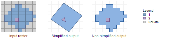
The output of selecting whether to simplify polygons
Steps
- Find the Raster to Polygon tool in the toolbox and double-click to open the tool's window.
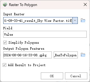
Raster to Polygon
Parameter Description:
- Input Raster: The input raster dataset; the raster data must be integer type.
- Field: This field assigns the pixel values from the input raster to the polygons in the output feature class.
Simplify Polygons (optional): Determines whether the output polygons will be smoothed into simpler shapes or retain the pixel edges of the input raster.
- Checked: Polygons will be smoothed into simpler shapes with the minimum number of segments, while approximating the original raster pixel edges as closely as possible. This is the default setting.
- Unchecked: Polygons will retain the exact edges of the input raster pixels. Using this option to convert the feature class back to a raster will produce a raster identical to the original.
Output Polygon Features: The output feature class containing the converted polygons.
- Add Result to Project: This option is only applicable if the output feature class is saved to a geodatabase within the current project. When checked, it will automatically create a layer for the result data and add it to the project.