Feature To Polygon
Function Description: Creates a feature class containing polygons generated from closed areas defined by input line or polygon features.
Data Description
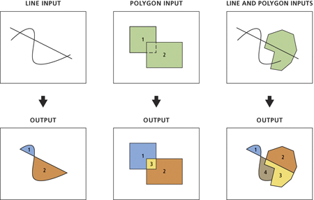
Input and Output Relationships:

Input and Output Relationships for Feature to Polygon
Notes:
- A new polygon feature will be created and written to the output feature class at the locations where one or more input features form closed areas. The output attributes will vary based on the Preserve Attributes and Label Features parameters.
- When multiple feature classes or layers are specified in the input list, the order of these entries does not affect the output feature type. However, the spatial reference of the output will be based on the top entry in the input list as specified in the tool dialog.
- If the Preserve Attributes parameter is checked, the output attribute schema and field values will depend on whether label features (points) are provided:
- If the Label Features parameter is not provided, the attribute schema (field names and attributes, excluding field values) for each input entry will be preserved in the output, in the order listed in the input list. A new field FID_xxx (where xxx is the name of the source feature class for a specific input entry) will be added to each output feature and set to -1. All other fields will include zero or null values.
- If the Label Features parameter is provided, all input attribute schemas will not be preserved in the output feature class, which will contain only the attributes from the label features. If an output polygon contains a label feature, it will receive field values from that label feature. If an output polygon contains multiple label features, it will receive field values from one of the label features. If an output polygon does not contain a label feature, its field values will be zero or null.
Steps
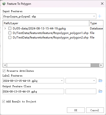
Locate the Feature To Polygon tool in the toolbox and double-click to open the tool's dialog window.

Feature To Polygon
Parameter Description:
- Input Features: Input features can be lines, polygons, or a combination of both.
Preserve Attributes (optional): Specifies whether to retain or ignore input feature attributes in the output feature class.
- Checked - Retains input attributes in the output features (if annotation features are present, the output features will contain only the attributes of the annotation features). This is the default setting.
- Unchecked - Retains the input attribute fields in the output features, but the field values will be empty.
Label Features (optional): Optional input point features that contain attributes to be transferred to the output polygon features.
Output Feature Class: The output polygon feature class.
- Add Result to Project: This option is only valid if the output feature class results are directed to a geodatabase within the project. When checked, a layer for the resulting data will be automatically created and added to the project.