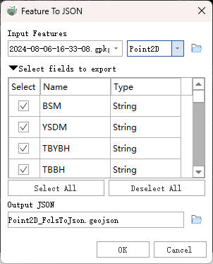
Features To JSON
Function Description: Converts features to Esri JSON or GeoJSON format. The fields, geometry, and spatial reference of the features are converted into the corresponding JSON representation and written to a file with the extension .json or .geojson.
Note: The GeoJSON specification defaults to the WGS 1984 coordinate system.
Data Description
- Once exported as a
.geojsonfile, the output will include acrstag that may be used by some applications to define the coordinate system or coordinate reference system. Note that the GeoJSON specification does not fully support this tag.
Steps
Find the Feature To JSON tool under the toolbox and double-click to open the tool's window.

Features To JSON
Parameter Description:
- Input Features: The features to be converted to JSON format.
- Select Fields to Export: Check to choose which fields to export to the Output JSON.
- Output JSON: The .json or .geojson file to be created.