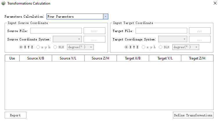
Transformations Calculation
Steps
1.Open the toolbox, Click on Data Management > Point Cloud Tools > Projection and Coordinate Transformation >Transformations Calculation, and a dialog box will appear.

Description
- Parameters Calculation : The method for parameter calculation supports Four Parameters and Seven Parameters.
- Input Source/Target File : Input the source coordinate file for control points; the format can be referenced from Seven Paras Input Format.
- Input Source/Target Coordinate :When the coordinate format x y h / BLH is selected, you can choose a coordinate system. Refer to Define Projection.
- Input Source/Target Coordinate Format:
- X Y Z(Geocentric Coordinate System): When the input data is in a projected coordinate system or a geocentric coordinate system, you can select this option. In this case, "Source/Target Coordinate System" cannot be selected. The seven-parameter transformation between the source and target coordinates is directly calculated. If the user selects Four Parameters, it will be automatically switched to X Y Z.
- x y h / BLH: When the input data is in a projected or geographic coordinate system, select this option. At this time, you need to choose the "Source/Target Coordinate System." Once selected, an automatic conversion will be performed based on the chosen coordinate system. When selecting BLH, you can also choose the format for angle values, currently supporting "Degrees" and "Degrees: Minutes: Seconds."
- x y h: The "Source/Target Coordinates System" will first be projected to geographic coordinates based on the user's selected projected coordinate system. Then, the geographic coordinates will be transformed to the geocentric coordinate system using the ellipsoid information from the projected coordinate system. Finally, the seven parameters between the two geocentric coordinate systems will be solved.
- BLH: The user needs to select the "Geographic Coordinate System." The program will use the ellipsoid information from the selected geographic coordinate system to transform the coordinates to the geocentric coordinate system, and then solve the seven parameters between the two geocentric coordinate systems.
- Report: Calculate the transformation relationship and generate a report. The report includes the computed transformation parameters and the reprojection errors of each control point. The report can be saved in HTML and ASCII formats.
- Define Transformations: Refer to Create Transformation Relationship.
Seven Parameters Solution
Use Bursa model to calculate the seven parameters for the transformation among different coordinate systems according to three or more pairs of tie-points. The parameters include three translation parameters, dx, dy, dz, three rotation parameters, rx, ry, rz, and a scaling factor, m. The calculation formula is shown below. Bursa seven parameters formula can be written as follow:

Convert the above formula to a equation set, which is:

Four-parameter Solution
According to two or more control points, users can calculate the four parameters that used to perform coordinate system transformation. The four parameters include two translation parameters, dx and dy, a rotation parameter, T, and a scaling factor, K. For detailed information on the four parameters, please refer to Create Transformation Relationship.