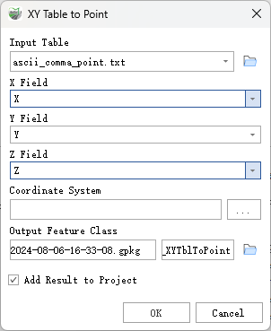
XY Table To Point
Function Description: Creates a point feature class based on X, Y, and Z coordinates in the table.
Data Description
- Standard delimiters for text files with extensions .csv or .txt are commas.
- Attribute fields from the Input Table parameter value will be transferred to the Output Feature Class parameter value.
- The coordinate system specified in the Coordinate System parameter will be applied to the output. This coordinate system determines how the X, Y, and Z coordinates in the input table are interpreted.
- When X Field and Y Field parameter values are 0 or null, they are considered valid and will be included in the output. Coordinates of 0 will place a point feature at that location, while null coordinates will result in empty geometry.
- In a geographic coordinate system, if X Field and Y Field parameter values are less than -400 or greater than 400, they are considered invalid. Output records will not be created for these, and a warning message will appear in the tool to indicate the invalid record IDs.
Steps
Find the XY Table To Point tool under the toolbox, and double-click to open the tool window.

XY Table To Point
Parameter Description:
- Input Table: The table defining the locations of the point features (containing X and Y coordinates).
- X Field: The field in the input table containing the X coordinates (or longitude).
- Y Field: The field in the input table containing the Y coordinates (or latitude).
- Z Field (Optional): The field in the input table containing the Z coordinates.
- Coordinate System (Optional): The coordinate system for the X and Y coordinates. This will be the coordinate system for the output feature class.
- Output Feature Class: The feature class that will contain the output point features.
- Add Result to Project: This option is only applicable when the output feature class is saved to a geodatabase in the project. If checked, the result data will automatically be added to the project as a layer.