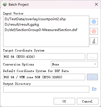
Batch Project
Function Description: Project a set of vector data from one coordinate system to another.
Data Description
If the input feature class includes data in .dxf format, you need to specify the default coordinate system information for the dxf data separately, as .dxf data cannot store coordinate system information itself.
The Transformation Options parameter is optional. Leave it empty if no geographic transformation or datum shift is needed; if transformation is required, select the seven-parameter settings for correct transformation.
- For example, no geographic transformation is needed when projecting from GCS_North_American_1983 to NAD_1983_UTM_Zone_12N because both the input and output coordinate systems use the NAD_1983 datum. However, a geographic transformation is needed when projecting from GCS_North_American_1983 to WGS_1984_UTM_Zone_12N, as the input coordinate system uses the NAD_1983 datum while the output coordinate system uses the WGS_1984 datum.
Note:
Transformations are bidirectional, meaning that if a transformation is required, both the input-to-target projection and the target-to-input projection need separate transformation parameters.
All data in the input set must have a consistent datum for transformations, otherwise, applying transformation parameters may result in errors.
It is recommended to project all input data to the same coordinate system before performing analysis.
You must first use the Define Projection tool to define the coordinate system for feature classes with undefined or "unknown" coordinate systems before using the Projection tool, otherwise, such data will fail to project.
The name of the input feature class is used to name the output feature class. For example, if the input is C:\test\point.shp, the output feature class will be named point.shp. If a name already exists in the output workspace, the system will append a number to the name (e.g., (1)) to ensure uniqueness (e.g., point(1).shp).
Steps
- Locate the Batch Projection tool under Vector Tools in the toolbox and double-click to open the function window.

Parameter Description:
Input Vectors: Feature classes to be projected, allowing for multiple vector data inputs.
Note: The coordinate system datums of all input vector data must be consistent, which means that the default coordinate system for DXF data must also meet this requirement.
Target Coordinate System: The coordinate system to which the input data will be projected.
Conversion Options (Optional): Used for transforming data between two geographic coordinate systems or datums. This optional parameter may be needed if the input and output coordinate systems have different datums.
Default Coordinate System for DXF Data (Optional): This parameter needs to be set if the selected input data is in .dxf format.
Output Directory: The directory where the resulting feature classes will be stored.