Orthophoto Generation from images
Steps
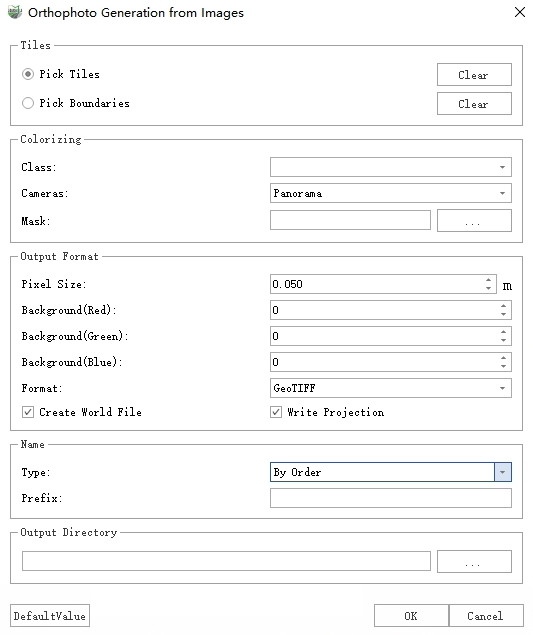
1.Click on the Road Analysis >> Orthophoto >> Generate Orthophoto from Photos button in the toolbox, and the following function dialog box will appear:
Orthophoto Generation from images
2.Set the mode, orthophoto parameters, and output directory, then click "OK" to run.
Parameters
Mode: Two generation modes are available — Tiles and Single Image.
Tiles: By selecting tiles and boundaries, orthophotos within the specified range are generated. First, single-image orthophotos are created, then merged into orthophotos within each tile.
Pick Tiles: When enabled, polygons generated by Place Tile Array or any arbitrary polygon can be selected in the 3D view. Clicking Clear will remove the selected tiles.
Pick Boundarise: When enabled, a polygon can be selected in the 3D view as the orthophoto boundary. Pixels outside the boundary will be set to the background color. Clicking Clear will remove the selected boundary.
Single Image: Generates an orthophoto for each individual photograph. Note: The maximum orthophoto range is defined by an OBB (Oriented Bounding Box) centered at the image position, extending 5 m forward and backward along the trajectory, and 3.5 m to the left and right.
- Pick Boundarise: When enabled, a polygon can be selected in the 3D view as the orthophoto boundary. Pixels outside the boundary will be set to the background color. Clicking Clear will remove the selected boundary.
Colorizing: Used for settings related to color assignment parameters.
Class: Select the point cloud categories to be used for generating orthophotos.
Cameras: Select the camera used for color assignment, supporting both panoramic and planar cameras.
Mask: Only available when Panoramic is selected in Camera, it is used for setting the mask file.
Output Format: Set the pixel size, background color, and output file format.
Pixel Size: The physical size represented by a single pixel.
Background(Red|Green|Blue): Set the background color for the orthoimage, with a range of 0 to 255.
Format: Supports two photo formats: GeoTIFF and JPG.
Write Geotransformation: If checked, geographic coordinates and projection information will be written (directly into the GeoTIFF file, or into the corresponding world file *.jpw for JPG).
Name: Set the file name for the output orthoimage.
Type: There are two options: By Order and Using Tile Number.
By Order: The name will adopt the format "Prefix + Sequential ID (starting from 1)".
Use Tile Number: The tile's numbering will be used as the file name. If the tile does not have a number, the sequential mode will be used as the file name instead.
Prefix: Only available when the Type is selected as By Order.
Ouput Directory: Select the directory for generating orthophoto.