Multiple Ring Buffer
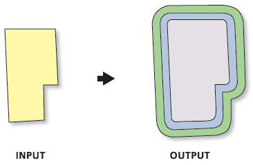
Function Description: Creates multiple buffers at specified distances around the input features. These buffers can be merged and dissolved using the buffer distance values to create nonoverlapping buffers.
Data Description
Input and Output Relationship

Input and Output Relationship for Multiple Ring Buffer
Notes:
If the "Non-overlapping (ring)" option is specified for the "Merge Options" parameter, the output feature class will contain one feature for each distance specified in the "Distance" parameter. All buffers at the same distance from the "Input Features" will be merged together.
When buffering polygon features, a negative buffer distance can be used to create buffers inside the polygons. A negative buffer distance will shrink the polygon boundaries inward by the specified distance.
Note: If the negative buffer distance is large enough to reduce the polygon to nothing, an empty geometry will be generated. A warning message will appear, and no empty geometries will be written to the output feature class.
Steps
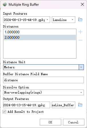
- Locate the Toolbox -> Vector Tools -> Overlay Analysis -> Multiple Ring Buffer tool, and double-click to open the tool window.

Multiple Ring Buffer
Parameter Description:
- Input Features: The input point, line, or polygon features to be buffered.
- Distances: A list of buffer distances. Multiple distance values can be entered, and negative values are supported for polygon features.
- Distance Unit (Optional): Specifies the linear units used with the distance values.
- Default: Uses the linear units of the input feature's spatial reference. If the spatial reference of the input features is unknown or undefined, it defaults to the data coordinate units. This is the default setting.
- Inches: Units in inches.
- Feet: Units in feet.
- Yards: Units in yards.
- Miles: Units in miles.
- Nautical Miles: Units in nautical miles.
- Millimeters: Units in millimeters.
- Centimeters: Units in centimeters.
- Decimeters: Units in decimeters.
- Meters: Units in meters.
- Kilometers: Units in kilometers.
- Decimal Degrees: Units in decimal degrees.
- Points: Units in points.
- Buffer Distance Field Name (Optional): The field name in the output feature class where the buffer distances used to create each buffer feature will be stored. The default is
distance. The field will be of double precision type. - Dissolve Options (Optional): Specifies how to merge the buffers.
- Non-Overlapping (Rings): Buffers are merged as concentric rings around the input features. The smallest buffer covers the input feature plus its buffer distance, and subsequent buffers form rings around the smallest buffer. All buffers of the same distance are merged into a single feature. This is the default setting.
- Overlapping (Disks): Buffers are not merged. All buffer areas are retained regardless of overlap. Each buffer covers its input feature plus any smaller buffers.
- Outside Polygons Only (Optional): Specifies whether the buffer will cover the input feature. This option applies only to polygon input features.
- Unchecked: Buffers will overlap or cover the input features. This is the default setting.
- Checked: Buffers will form rings around the input features and will not overlap or cover the input features (areas inside the input polygons will be erased from the buffer).
- Output Features: The feature class containing multiple buffer features.
- Add Result to Project: This option is only available when the output feature class is saved to a geodatabase within the project. Checking this option will automatically create a layer for the result data and add it to the project.