Feature to KML
Function Description: Converts a feature class to a KML file.
Data Description
Keyhole Markup Language (KML) is an XML-based format for storing geographic data and associated content, and it is an official Open Geospatial Consortium (OGC) standard. The KML format is convenient for publishing on the Internet and can be viewed using many free applications, making it commonly used for sharing geographic data with non-GIS users. KML files use the extensions .kml or .kmz (for compressed KML files).
All KML and KMZ files are created in the WGS84 coordinate system. If the layer is not in WGS84 coordinates, ensure that it is properly projected. If projection transformation is needed, use the Projection tool to reproject the data before converting to KML.
KML can consist of point features, line features, polygon features, and raster images.
Note: LiDAR360MLS supports only point, line, and polygon features in KML.
Steps
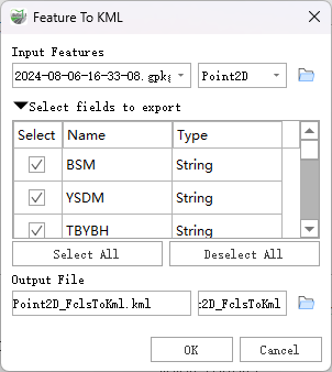
Find the Feature To KML tool in the toolbox and double-click to open the tool's dialog box.

Feature to KML
Parameter Description:
Input Features: The feature class to be converted to KML.
Select Fields to Export: Check the fields to be included in the output KML.
Output File: The KML file to be created.
Note: Outputting a .kmz file is a compressed KML file using ZIP compression, and it is viewed and handled in the same way as a KML file.