3D ASCII File to Feature Class
Function Description: Import 3D features from one or more ASCII files stored in XYZ, XYZI, or GENERATE format into a new feature class.
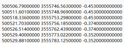
Data Example

Sample Data
Description:
All input files must have the same format and geometry type.
XYZ and XYZI formats support header rows and interpret the first line starting with three consecutive integers as the beginning of point records. Both formats can store points, lines, and polygons, but each file can only store one single-part line or polygon feature. Polygon features must be closed, with the coordinates of the last vertex equal to those of the first vertex, and must not self-intersect.
XYZ files store x, y, and z coordinates as floating-point values, with each line in the file representing a different point record.
XYZI files can store x, y, z, and intensity measurement values.
GENERATE format does not support header rows but can provide an ID for each point along with XYZ coordinates. The last line of the file can optionally be marked with the END keyword.
id x y z
id x y z
.
.
END
The GENERATE format supports multiple features per file. For lines and polygons, the END keyword is used to indicate the end of a feature, and each feature must be a single-part feature. Two END keywords on a line indicate the end of the file.
id x y z x y z x y z END id x y z x y z END ENDNote: Polygon features should be oriented in a clockwise direction, must not self-intersect, and should be closed (i.e., the last vertex should be the same as the first vertex). Any deviation from these conditions will result in an invalid polygon in the output.
Steps
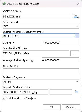
Find the 3D ASCII File to Feature Class tool in the toolbox and double-click to open the tool's window.

3D ASCII File to Feature Class
Parameter Description:
ASCII 3D Data: ASCII files or folders containing XYZ, XYZI (with LiDAR intensity), or 3D GENERATE format data. All input files must have the same format. If a folder is specified, the File Suffix parameter becomes mandatory and will process all files with the specified suffix.
File Format: The ASCII file format to be converted to a feature class.
- XYZ—Text files containing geometry information stored as XYZ coordinates.
- XYZI—Text files containing both XYZ coordinates and intensity measurement values.
- GENERATE—Structured text files in GENERATE format.
Output Feature Class Type: The geometry type of the output feature class.
- Multipoint Feature—Recommended if the input data contains many points and attributes that are not needed for each feature.
- Point Feature—Each XYZ coordinate will generate a point feature.
- Polyline Feature—The output will include polyline features.
- Polygon Feature—The output will include polygon features.
Z Factor (optional): A coefficient by which Z values will be multiplied. This value is typically used to convert Z linear units to match X and Y linear units. The default value is 1, which keeps elevation values unchanged.
Coordinate System (optional): The coordinate system of the input data. Defaults to "None."
Average Point Spacing (optional): The average planar distance between input points. This parameter is only available when the output geometry is set to MULTIPOINT and provides an average value to group points together. Specify the spacing in horizontal units of the target feature class.
File Suffix (optional): The suffix of the files to be imported from the input folder. This parameter is required if a folder is specified as input.
Decimal Separator (optional): The decimal separator used in the text file to distinguish the integer part of the number from its decimal part.
- Period—Uses a period as the decimal separator. This is the default setting.
- Comma—Uses a comma as the decimal separator.
Output Feature Class: The generated feature class.
Add Result to Project: This option is only applicable if the output feature class is saved to a geodatabase within the current project. When checked, it will automatically create a layer for the result data and add it to the project.