Feature to Raster
Function Description: Converts features into a raster dataset.
Data Description
- Any feature class containing point, line, or polygon features can be converted to a raster dataset.
- The type of the input field determines the type of the output raster. If the field is integer, the output raster will be integer; if the field is floating point, the output raster will be floating point.
- If pixel size is specified numerically, the tool will apply it directly to the output raster.
- This tool always uses the pixel center to determine the value of raster cells. For more control over the conversion of different types of input feature geometries, use the specific conversion tools: Point to Raster, Polyline to Raster, and Polygon to Raster.
- For data formats that support Null values, such as file geodatabase feature classes, Null values used as input will be ignored.
Steps
Find the Feature to Raster tool under the toolbox and double-click to open the tool window.

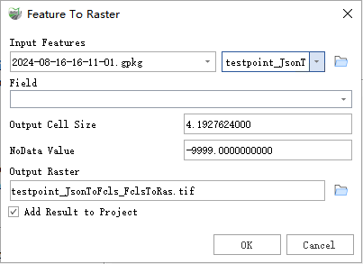
Feature to Raster
Parameter Description:
- Input Features: The input feature dataset to be converted to a raster dataset.
- Field: The field used to assign values to the output raster. It can be any numeric field from the attribute table of the input feature dataset.
- Output Cell Size: The cell size of the output raster being created.
- NoData Value: The value used to specify the location of invalid areas in the raster.
- Output Raster: The output raster dataset to be created.
- Add Result to Project: If checked, a layer for the result data will be automatically created and added to the project.