Interpolation Parameters Setting
When generating terrain products, you need to set some grid cell size parameters and determine the interpolation method used for grid cell calculations. The parameters settings are divided into conventional and standard.
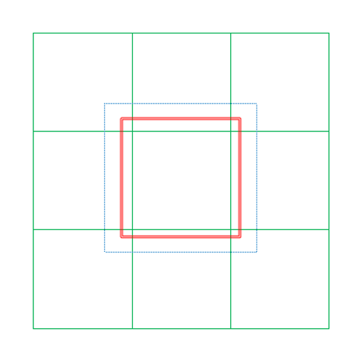
Under the standard parameters, the schematic diagram of the framing frame and each corresponding range is as follows:

Green box: standard framing box range;
The red double-line box: the result range box (the expansion range is related to the scale M, which is 0.01/M (m), for example, the scale is 1: 500, and the expansion range is 5m), and the range is calculated according to the internal scale;
Blue dotted frame: In the process of DEM generation, the size of the buffer area is expanded outside the result range frame to ensure the same elevation in the overlapping range of adjacent frames.

Parameter Type
- General: General DEM parameter configuration.
- Standard: Configured according to standard DEM production parameters.
Grid Size
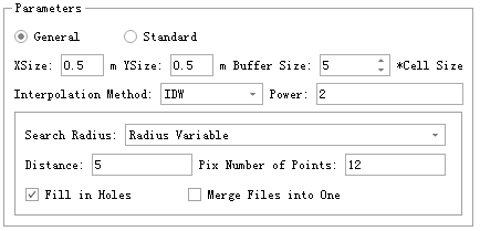
Through XSize and YSize, users can set the size of sampling interval (resolution) in meters. For instance, if XSize and YSize values are set to 2, respectively, the grid unit size is 2 meters by 2 meters.
Output with Point Cloud Name (Only for Standard Mode)
Check this option to prefix the output file name with the name of the first input point cloud.
Scale bar (only set under standard mode parameters)
The scale of the framed frame.
Buffer size
- Buffer Size (cell) (default is "5"): The size of each block of raster data extending around, in unit of cell.
Interpolation Methods
LiDAR360 provides three kinds of raster cell interpolation methods: IDW (Inverse Distance Weigh) interpolation, kriging interpolation, and TIN (Triangulated Irregular Network) interpolation.
IDW
In the inverse distance weighting interpolation method, the value of a grid element is computed using its nearby points, and the weighted average value is judged by the distance of the center point of the grid unit. Users need to set the weight value. The search radius can be used to define the input points of each raster image meta value interpolation, which consists of variable radius and fixed radius.
Power(default value is "2"): The power of the sampling point to the center distance of the pixel to control the degree of the influence of the sampling point elevation on the pixel center.
Radius Variable: Use a "Variable" to find a specified number of sampling points for interpolation.
- Distance(Pix)(default value is "5"): Restricts the distance to search for adjacent points, by default 5 pixels.
- Pix Number of Points(default value is "12"): The number of nearest neighboring points used for interpolating, which is set 12 as default.
Radius Fixed: Interpolation using all points in a fixed radius range.
- Distance(Pix)(default value is "5"): The point within the range of the radius is used for interpolation, by default 5 pixels.
- PixNumber of Points(default value is "12"): The smallest number of points used for interpolation, which is set 12 by default. If required points were not found within the specified radius, it will increase the search radius until find the minimum number of points.
Kriging
The Kriging interpolation method computes the optimized covariance and uses the Gaussian process interpolation grid value. The search radius can be used to define the input points of each raster image meta value interpolation, which consists of variable radius and fixed radius.
Radius Variable: Use a "Variable" to find a specified number of sampling points for interpolation.
- Distance(Pix)(default value is "5"): Restricts the distance to search for adjacent points, by default 5 pixels.
- Number of Points(default value is "12"): The number of nearest neighboring points used for interpolating, which is set 12 as default.
Radius Fixed: Interpolation using all points in a fixed radius range.
- Distance(Pix)(default value is "5"): The point within the range of the radius is used for interpolation, by default 5 pixels.
- Number of Points(default value is "12"): The smallest number of points used for interpolation, which is set 12 by default. If required points were not found within the specified radius, it will increase the search radius until find the minimum number of points.
TIN
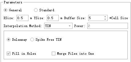
Extracts a grid cell value from a surface formed by a plurality of triangles consisting of the nearest adjacent point. This tool offers two options of interpolation.
Delaunay: Create the Delaunay triangulation by traditional point-by-point insertion. All the points will be involved.
Spike Free TIN: Remove all the points with abnormal altitude. It can lead to generating triangulated network without obvious spikes.
- Freeze Distance (default value is "1.0 meter"): The shortest distance in xy plane of each side of triangle in the triangulated network. When inserting a new point and its Z value lower Insertion Buffer, freeze all the triangles whose three sides are all less than Freeze Distance. The frozen triangles will no longer change. The larger this value is, the fewer points will be involved in creating the network, the more smooth the network will be and the less details will be included. Conversely, more points will be involved in creating the network, the more details will be included and the more possible spikes will appear in the network.
- Insertion Buffer (default value is "0.5 meter"): When trying to freeze a new triangle right after freezing another one, the difference in altitude value should be lager than this threshold. Decreasing this value will result in more triangles will be frozen too early, new point cannot be inserted, less spikes will appear, processing will be faster, and more details will be lost. Conversely. more details will be included, and more spikes will be included in the network.

    @inproceedings{
        author={ Khosravipour A, Skidmore A K, Isenburg M},
        title={Generating spike-free digital surface models using LiDAR raw point clouds: A new approach for forestry applications},
        booktitle={ International journal of applied earth observation and geoinformation, 52: 104-114},
        year={2016}
    }
Merge files into one
If this option is not checked, each point cloud data will be processed separately, resulting in more than one grid file. Check this option to merge all generated raster files into one file.
Fill in holes
If there are no points near the grid unit, the grid cells may not have data values. When this option is checked, data values can be computed by analyzing adjacent grid units and using the selected interpolation method to fill in an area with no values.
Note: The "Fill in holes" function is only for closed holes.