DEM Sheet Join
Functional Overview
By processing the border area of the digital elevation model of adjacent frames, the same grid point elevation within the overlapping range is guaranteed to be consistent.
Usage
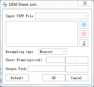
- Click Terrain > DEM Sheet Join, the DEM Sheet Join interface will pop up:

Click
to add the DEM file and select the digital elevation model file of the edge to be connected (currently only .tif format is supported);
Set the parameters, and click OK to execute the DEM Edge Alignment.
Parameters Settings
- Resampling: The method used for resampling the overlapping area.
- Nearest Neighbor sampling (default): The nearest neighbor method, sampling from the nearest neighbor.
- Bilinear sampling: Bilinear sampling (2 x 2 kernel).
- Cubic convolution approximation: Cubic Convolution Approximation (4×4 kernel).
- Cubic B-spline approximation: Cubic B-spline approximation (4 x 4 kernel).
- Lanczos window sinusoidal interpolation: Lanczos Windowed Sine Interpolation (6 x 6 kernel). Lanczos can be used as a low-pass filter or to smoothly interpolate between its samples The value of the digital signal.
- Average sample: Calculates the average of all non-null pixels.
- Statistical sample: Select the value that occurs most frequently among all sampling points.
- Sheet frame (optional): Add a frame. If no framing frame is added, it will be saved in the original size of each DEM file; if a framing frame is set, the framing will be performed according to the framing frame.