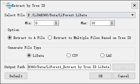
Extract by Tree ID
Summary
This function is used to extract part or all point clouds from the segmented point cloud based on Tree ID. When exporting the data into one file, the optional formats include LiData, CSV, and LAS. When exporting the data into multiple data, the optional format will be CSV file only.
Usage
Navigate to ALS Forest > Extract Point Cloud by Tree ID.

Settings
- Select File: Select the point cloud data with segmented tree ID information from the drop-down list. Only one file can be selected at a time, and it has to be opened in LiDAR360 already.
- Min (default value is "0"): The minimum value of tree ID to be extracted. The default value is zero.
- Max: The maximum value of tree ID to be extracted. The default value is the number of trees in the point cloud. If the point cloud has not been segmented, the minimum and maximum values of the tree ID are both zero.
- Extract to A File (default): The point cloud in the selected range is extracted into a CSV, LiData, or LAS file that contains the X, Y, Z coordinates and tree ID information.
- Extract to Multiple Files Based on Tree ID: Extract the point cloud data based on tree ID and save them as different CSV files for each tree. The stored information are X, Y, Z coordinates and tree ID information for each tree.
- Output Path: Output path for the results.