Subdivision
Summary
Subdivision tool can divide a point cloud to a series of frames based on the user defined scales. Currently, for rectangle-division, LiDAR360 supports four subdivision scales: a scale of 1:5000 (taken to 1 km), 1:2000 (taken to 0.1 km), 1:1000 (taken to 0.1 km), and 1:500 (taken to 0.01km). The frame ID will be named by the coordinate number, which is composed of the southwest corner of the frame (Y coordinate + X coordinate). After the operation is completed, one or multiple LiData file will be generated. A vector file in shp format will also be generated recording each subdivided frame.
Usage
Click Data Management > Point Cloud Tools > Subdivision

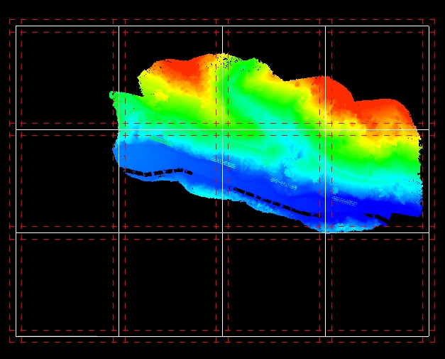
After completing the parameter settings, click the Preview button to check the subdivision grid. The white solid lines indicate the block boundaries, while the red dashed lines represent the buffer zone. Only rectangular subdivision previews are supported, and previewing is only allowed when all selected point cloud files are within the current window.

Settings
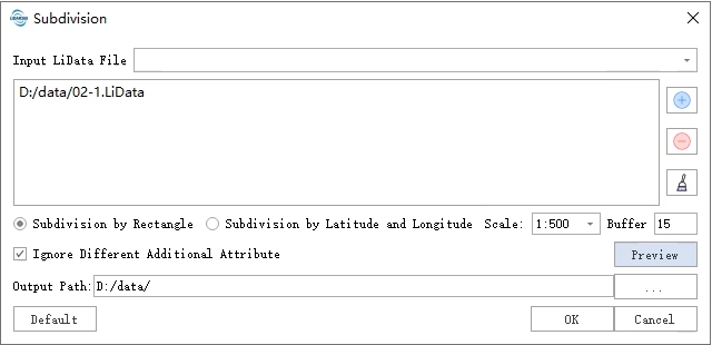
- Input LiData File: Input the point cloud data to be subdivided. If the point cloud data is already open in the software, click the drop-down button to select the data; or you can click
to open external point cloud data. Click
to remove the selected data. Click
to clear the data list. File format: *.LiData.
- Subdivision by Rectangle: Use "Subdivision by Rectangle". Scale is 1:500 by default.
- Subdivision by Latitude and Longitude: Use "Subdivisions of Graticules". Scale is 1:500 by default.
- Scale: Users can choose the scale of the division. For rectangle-division, LiDAR provides four scales, including 1:500, 1:1000, 1:2000, 1:5000. For subdivisions of graticules, LiDAR provides eleven scales, including 1:500, 1:1000, 1:2000, 1:5000, 1:10000, 1:25000, 1:50000, 1:100000, 1:250000, 1:500000, 1:1000000.
- Buffer (default is "0"): The size of buffer around each data.
- Ignore Different Additional Attribute: In the case of processing multiple input point clouds, if this option is checked, only the same additional attributes will be merged. Otherwise, as long as there are different additional attributes, the merge cannot be performed.
- Output Path: The path for the output folder. After running this function, the new divisions will be generated.