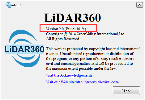
How to check the version information of LiDAR360 software?
- You can check the version information of LiDAR360 in Help > About, 2.0 is the software version and 1019 is the build date.

How to change the menu language?
- Click Display->Language in the menu bar to switch between English, Chinese, Japanese, French, Korean, and Spanish.
Why does the software exit abnormally?
- Based on our experience, the major two reasons of abnormal exits are the insufficient disk space or memory space in your computer and the existence of opened instance of screen word capturing software. If you meet any other scenarios that lead to abnormal exits, please contact us info@greenvalleyintl.com.
What are the supported data formats in LiDAR360?
LiDAR360 can import the following data formats:
- Point Cloud: LiData files (*.LiData custom point cloud format), LAS files (*.las,*.laz), ASCII files ( *.txt, *.asc, *.neu, *.xyz, *.pts, *.csv), PLY files (*.ply), E57 files (*.e57), PCD file (*.pcd).
- Raster: Image File(*.tif,*.jpg).
- Vector: Vector File(*.shp).
- Table: Table File(*.csv)
- Model: Proprietary Model File(*.LiModel), Proprietary TIN File*.LiTin), OSG Model File(*.osgb, *.ive, *.desc, *.obj).
LiDAR360 can export the following data formats:
- Point Cloud: LiData files (*.LiData custom point cloud format), LAS files (*.las,*.laz), ASCII files ( *.txt, *.asc, *.neu, *.xyz, *.pts, *.csv), PLY files (*.ply), E57 files (*.e57), PCD file (*.pcd).
- Raster: Image File(*.tif,*.jpg).
- Vector: Vector File(*.shp, *.dxf)
- Table: Table File(*.csv)
- Model: Proprietary Model File(*.LiModel), Proprietary TIN File(*.LiTin).
How to fix drag and drop in windows 8 and windows 10?
- Go to RUN, or search "regedit.exe" then run as administrator. On Registry Editor go to: HKEY_LOCAL_MACHINE\SOFTWARE\Microsoft\Windows\CurrentVersion\Policies\System, double click "EnableLUA", and change the value from 1 to 0. Restart windows, and the problem will be solved. Reference.
Why is the EDL visual effect not obvious if multiple data are added in the same window?
- It's recommended to show distant multiple data in separate windows with EDL effect. Or remove unwanted data in the current window.
What is the unit of point cloud data in LiDAR360?
LiDAR360 V5.2 and later supports user-defined unit settings. You can set custom units through "Display Settings" -> "Measurement Settings" in the upper right corner of the window. Currently supported units are meters, feet, decimeters, centimeters, millimeters, and inches.
How to subsample the point cloud uniformly?
LiDAR360 provides subsampling methods by Minimum Points Spacing, Sampling Rate, or Octree. The subsampling by Octree is an uniform method.
Click Data Management > Point Cloud Tools > Subsampling, then select the sampling type Octree.
How to Pick Rotation Center while using the Pick Multi-Point tool?
- Hold the Ctrl key and pick rotation center by left-click.
Why are point cloud transformation results incorrect in LiDAR360?
- This is because different units are used in each program. In LiDAR360 degree units are used. In order to carry out a correct transformation, the units must be degrees.
Can lidar data or software be built into a GIS Platform?
- Yes. Our software can generate shapefiles (.shp) and .tiff files which can be integrated into a GIS system. In our software you can also create new polygons, lines as well as generate contour lines, DEM and other digital models.
What memory(RAM) requirement is there to process large datasets in LiDAR360?
- We recommend at least 16GB of RAM for processing large datasets.
Why there are very large error after rectifying? How to solve it?
- You can view the residuals for all the homologous points pairs and remove the homologous points pairs with large residuals. After that, redo the rectifying process.
Why does the dialog box text appear incomplete or garbled when viewing single point cloud information?

- Update the discrete graphics card driver to the latest, and then run the software in high-performance graphics mode. To adjust the high-performance display mode under the Win10 operating system, please refer to Set high-performance display mode.
Why is DJI L1 data a straight line when opened through LiDAR360 (data display is incorrect)?
- This situation is because LiDAR360 supports the display of projected coordinates, and it is necessary to convert geographic coordinates to projected coordinates
- Data management -> point cloud format conversion -> Las conversion to LiData to select the projection coordinates, and the converted data can be displayed correctly by re-importing it into the software.
The startup time of LiDAR360 software is too long, can I troubleshoot computer performance problems?
- Analysis of the reason for this situation is that the configured group authorization cannot be connected, and the software startup caused by the time delay is too slow. The solution: (1) Find the bit_config.xml file in the folder and delete it; (2) Where the software configures the authorized IP address of the group, find the corresponding file and delete it.
