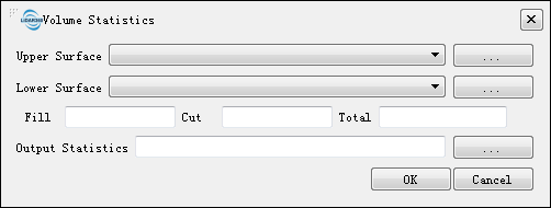
Volume Statistics
Summary
LiDAR360 supports the use of surface model data (single-band tif data) with spatial overlaps to calculate volume statistics. By subtracting the lower surface from the upper surface, the statistical filling amount (Fill), excavation amount (Cut ) and total fill volume (Total) (calculated by subtracting fill volume from volume of excavation) can be obtained.
Usage
Click Statistics > Volume Statistics

Settings
- Upper Surface: Users can select the *.tif format file from the drop-down list, or click
 to select external file.
 - Lower Surface: Users can select the *.tif fornat file from the drop-down list or click
 to select external file.
 - Output Statistics: Specify the path to output the statistical result as a *.txt format file. The file contains the path of the upper and lower surface files, spatial resolution, XSize, YSize, and the amount of the filler.
Note: The upper and lower surface files are single-band data, they must have the same spatial resolution and the spatial ranges have intersections. The unit of the point cloud data processed by LiDAR360 is meter, and the calculated fill volume, excavation volume, and total amount are in cubic meter.