Clip by Circle
Summary
Clip by circle tool extracts the point cloud data within user-defined circle(s), and the extracted points can be saved in one or multiple files.
Usage
Click Data Management > Clip > Clip by Circle
Settings
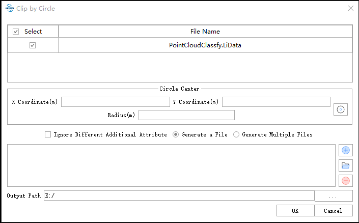
- Input Data: Input one or more point cloud data files. File Format: *.LiData.
- X Coordinate (m): Enter the X coordinate of the circle center.
- Y Coordinate (m): Enter the Y coordinate of the circle center.
- Radius (m): Enter the radius of the circle.
- Ignore Different Additional Attributes: When inputs are several point cloud files, and this option is checked, only the same additional attributes of the point cloud files will be merged. If this option is unchecked, and there are some different attributes in the additional attribute tables, the mergence of different point cloud files cannot be done.
- Generate a File: Extract all the point cloud data within 2D circle(s) to one file.
- Generate Multiple Files: Extract the point cloud data within each circle and save them to one individual file. The file is named by its center and radius by default.
 :After clicking this button, users will be able to draw circle in the current window. Single-click to choose the center of the circle, and drag the mouse to change the size of the circle. Double-click to end the selection. The coordiantes of the center of circle and the radius of the circle will be displayed in the window.
 : Click this button to add the coordinates and radius of a circle to the processing list. Perform the same operation to add multiple clipping circles.
 : Click this button to load external data files. The file format refers to the Clip Range File Format in the appendix.
 : Click this button to remove the selected row(s) in the processing list.
- Output path: The generated file will be saved in this output path.