CHM Segmentation
Summary
CHM segmentation utilizes the watershed segmentation (Chen et al., 2006) technique to identify and delineate individual trees, and therefore obtain individual tree information, such as tree location, tree height, crown diameter, crown area and tree boundaries.
Principle
The basic principle of watershed segmentation algorithm is if placing a water source in each regional lowest point in the CHM and flooding the entire relief, barriers can be generated when different water sources meet. The resulting set of barriers can build a watershed by flooding, which is the segmentation result. Note that the CHM segmentation result can be affected by the CHM resolution. It is recommended that the CHM should have a spatial resolution higher than 1 m to ensure a sufficient segmentation result. Moreover, the CHM segmentation result can also be largely influenced by tree density and tree species. If the algorithm does not work well in certain study area, users can try to use other segmentation algorithms to get the best segmentation result.

(a) CHM; (b) Watershed Segmentation Algorithm; (c) CHM Segmentation Result
Usage
Navigate to ALS Forest > Segmentation > CHM Segmentation.

Settings
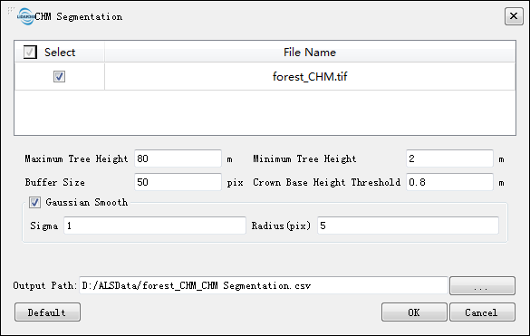
- Input Data: The input file can be a single CHM file or multiple CHM files. The data should be opened in LiDAR360 before being processed.
- Maximum Tree Height (meter)(default value is "80"): The threshold defining the maximum tree height in a study areas. CHM pixels above this threshold will not be considered in the segmentation.
- Minimum Tree Height (meter)(default value is "2"): The threshold defining the minimum tree height in a study areas. CHM pixels below this threshold will not be considered in the segmentation.
- Buffer Size (pix)(default value is "50"): A threshold controls the block size for performing CHM segmentation, which can avoid physical memory overflow. This value should be larger than the maximum crown area and smaller than 1500. If the CHM is larger than 1500 by 1500 pixels, the CHM will be forced to divided into a number of blocks with a size of 1500 by 1500 pixels.
- Crown Base Height Threshold (meter)(default value is "0.8"): The starting height of the crown range. A reasonable base height value can help to improve the accuracy of the boundary and area of crown. After setting the base height, the pixels higher than this height will be included to generate the vector boundary of crown, while the pixels lower than this height will be excluded. Users should set this value according to the species and growing situation of the trees in order to get the best result.
- Gaussian Smooth (optional): This parameter is to control whether to perform Gaussian smoothing. In general, it is recommended to check the Gaussian smoothing option to remove noise effects.
- Sigma (default value is "1"): Gaussian smoothing factor. The greater the value is, the smoother the results are. The degree of smoothness can affect the number of trees being segmented. In the case of under-segmentation, it is recommended to reduce this value (e.g. 0.5); and in the case of over-segmentation, it is recommended to increase the value (e.g. 1.5).
- Radius (pix)(default value is "5"): The window size used by Gaussian smoothing, which should be an odd number. Generally, it can be set to the average crown diameter.
- Output Path: Path of the output file. The resultant product is a comma-separated table in “csv” format and a polygon file in "shp" format. The CSV table contains the ID, location (x and y coordinates), height, crown diameter, and crown area of each segmented tree. The shp file contains the boundary of each tree, and its corresponding attribute table contains the ID, location (x and y coordinates), height, crown diameter, and crown area of each segmented tree. Refer to the CHM Segmentation Results for segmentation result examples.
- DefaultValue: Restore the default parameters.
Note: The CHM Segmentation function can only be used when the raster data is loaded in the software. Otherwise, the message “There is no raster data!” will pop up.
    @inproceedings{
        author={Chen Q, Baldocchi D, Gong P and Kelly M},
        title={ Isolating Individual Trees in a Savanna Woodland Using Small Footprint Lidar Data},
        booktitle={Photogrammetric Engineering and Remote Sensing, 72(8): 923-932},
        year={2006},
    }