DOM
Functional Overview
DOM (Digital Orthophoto Map) refers to aerial photos that have been geometrically corrected and possess both map geometric accuracy and image features. This function uses the results of aerotriangulation project to generate DOM.
Usage
To generate digital orthophoto images, it is necessary to import the aerotriangulation project from various software and convert them into LiDAR360's internal image project files. Then, use the DEM or DSM function within the terrain module to interpolate the corresponding area's point cloud files and generate a DEM or DSM.
ClickTerrain > DOM。
Parameters Settings
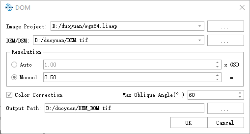
- Image Project: Select the imported image project file.
- DEM/DSM: Select the generated DEM or DSM file, supporting single channel TIFF files with 32-bit depth.
- Resolution: The resolution can be set in two modes. When selecting the automatic mode, the program will automatically calculate the ground sample distance (GSD), and the parameter set is a multiple of the GSD. When selecting the manual mode, the DOM resolution can be set directly.
- Color Correction: Whether to perform color correction on the photos to reduce color difference for some photos. This is only effective for image projects containing tie points.
- Occlusion Detection: This parameter determines whether to perform occlusion detection during orthorectification. For urban oblique photogrammetry scenarios, it is recommended to enable this option to reduce occlusion caused by buildings. For forest data combined with point clouds, due to the penetration capability of LiDAR, the generated DEM/DSM, etc., may not require occlusion processing, so it is recommended to disable this option.
- Maximum Oblique Angle: Only use photos with oblique angles less than this value for orthorectification.
- Output Path: Save the generated DOM file to the specified path.
In automatic mode, the calculated resolution will not be less than 0.05 meters.