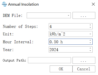
Annual Insolation
Function Overview
Annual Insolation is used to estimate the annual solar radiation within a specific area. It samples time points throughout a year according to specified parameters, calculates insolation for each sampling time (day), and outputs a multiband dataset recording insolation values for each time sample. This can be used to assess trends in annual solar radiation for the area.
Usage
Click on Terrain > Spatial Analysis > Annual Insolation.
Parameter Settings
- DEM File: Input Digital Elevation Model (DEM) file. Refer to DEM Generation for methods of generating DEM.
- Number of Steps: The number of sampling days for the selected year. This parameter controls the temporal accuracy of the calculation. It determines how many days within the year the sun’s position and radiation are calculated. The selected year is sampled at specified intervals, and only the insolation for those sampled days is calculated. Each sampled day's solar radiation is exported as a band. For example, with a step of 4, the result will generate 5 bands: the first band is January 1st, followed by sampling at intervals of 4 steps, resulting in approximately 5 bands: January 1st, April 1st, July 1st, October 1st, and December 31st. Adjustment suggestion: A higher value yields more detailed results but takes longer. For annual calculations, 6 is a commonly used value that balances accuracy and efficiency. If higher temporal resolution is needed for research, it can be increased to 8 or 12.
- Units: Defines the unit of output radiative energy. Kilowatt-hour/square meter: Recommended for engineering applications, an industry standard in energy fields, very intuitive and easy to directly compare with photovoltaic power generation. Kilojoule/square meter, Joule/square centimeter: Other energy units commonly used in scientific research and specific domain literature.
- Hour Interval: The time sampling interval for solar radiation calculation on the sampled day. The default is 0.5, which means a sampling interval of 0.5 hours (30 minutes), i.e. 48 samples per day. The solar radiation output for the sampled day is one band, with the value being the total daily insolation.
- Year: Specifies the year for the calculation. Solar radiation calculations need to consider leap years, orbital parameters of the sun, and other astronomical factors. Setting it to 2024 means using the 2024 calendar to calculate the sun’s position and daylight duration. Calendars vary slightly by year (especially leap years have 366 days), which affects the total annual radiation calculation. It should be set to match the actual analysis year. For multi-year averages, it is recommended to use a representative year.
- Resampling: Performs resampling processing based on the raster pyramid. Different pyramid levels and resolutions are determined by the specific data, with each successive layer downsampled at a 2:1 ratio.
- Resolution: The resolution of the raster. For raster data with fewer than 1000 rows or columns, lower-level resolutions will not be displayed. Higher selected resolutions yield more accurate results but may fail due to insufficient hardware resources.
- Resampling Method: The raster resampling method.
- Output Path: The path for outputting the multi-band TIF data.