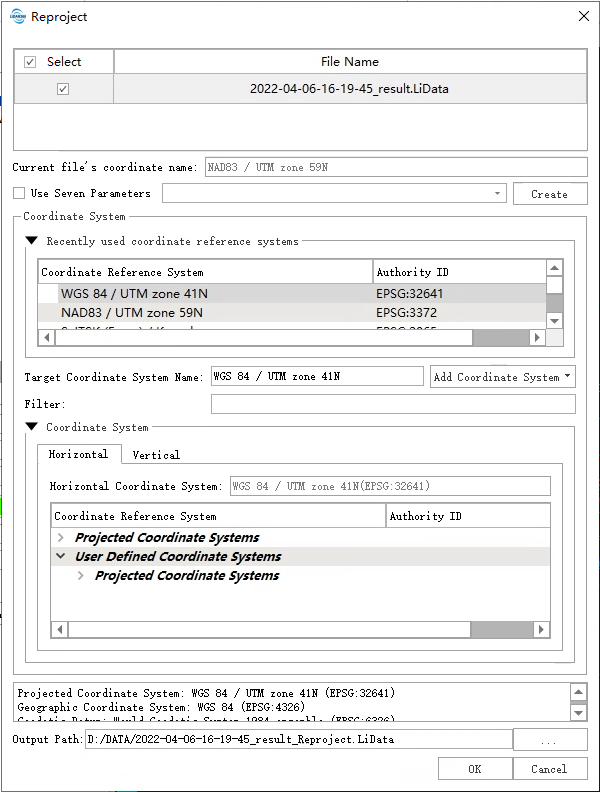
Reproject
Function Description
The point cloud can be reprojected among geographic coordinate systems and projected coordinate systems. When different geographic coordinate systems are converted to each other, LiDAR360 provides the seven parameter transformation model to adjust the differences between ellipsoids and reference planes.
Usage
Click Data Management > Projections and Transformations > Reproject

Settings
- Select Input File: The input file can be a single point cloud data file or multiple data files. File Format: .LiData, .tif, .shp, .gpkg
- Current File's Coordinate Name: Display the coordinate system name of the current point cloud.
- Use Seven Parameters: Users can choose whether to use seven parameters for re-projection. If checked, seven parameters will be used; vice versa.
- Seven Parameters Setting: Select the Use Seven Parameters option and click the Create button to create a seven-parameter conversion relationship. Please refer to Create Transformations.
- Filtering: Users need to enter a customized coordinate system. By entering the coordinate system keywords, the corresponding coordinate system can be filtered from the Coordinate reference systems of the world table (for example: to set the point cloud coordinate system to WGS 84 / UTM Zone 49N, users can enter UTM 49N in the filter for fast screening, or enter its EPSG number 32649 for quick search.) Users can also import external coordinate system by clicking the Add Coordinate System button.
- Add coordinate systems: For details, refer to Define Projection parameter settings.
- Output path: Path of the output file. New files will be generated after the function being executed.
Note: The reprojected point cloud must already have projection information. To check whether the current point cloud has projection information, users can select the data in the data list and its projection information will be displayed in the current file coordinate system