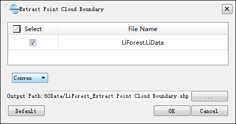
Extract Point Cloud Boundary
Functional Overview
Use a regular hexagon to extract the boundary of a point cloud data. At present, three types of boundaries are supported, namely hexagonal boundary, convex hull and concave hull. The ultimate output file is the final border vector file.
Usage
Click Data Management > Point Cloud Tools > Extract Point Cloud Boundary

Parameters Settings
- Input point cloud data: Input one or more point cloud data files. File format: *.LiData.
- Extraction Methods: Choose the method to extract the boundary. Currently supports three methods, hexagon, convex hull, and concave hull.
- Hexagon: Use regular hexagons to extract the boundaries of the point cloud data. Based on the hexagon height to determine the size of the hexagon. According to the bounding box of point cloud data, draw each hexagon. If the number of point clouds in the hexagon is greater than or equal to the set minimum number of points, draw the hexagon, merge the connected regular hexagon, and output the final boundary vector file.
- Hexagon Height (m) (default value is "10"): The height of the hexagon, which is used to set the size of a hexagon.
- Minimum Number of Points (default value is "1"): The threshold of points in a hexagon below which no boundaries are drawn.
- Convex Hull (default): Extract the convex hull of the point cloud in the X-Y plane (the z-value is ignored). The output file is the vector file (polygon) of the convex hull of the original point cloud.
- Concave Hull: Extract the concave hull of the point cloud in the X-Y plane (the Z-value is ignored). The output file is the vector file (polygon) of the concave hull of the original point cloud.
- Maximum Side Length (m) (default value is "2"): Each edge of concave hull has the maximum distance (Len) in the xy plane. As this value becomes larger, more long edges will be preserved and the resulting boundary will become more similar to the convex hull. On the contrary, more boundary details will be retained by the short edges, and the computational efficiency will be reduced. At this time, the program will automatically estimate the average distance between all the points, and set the parameter as twice of the average distance.
- Hexagon: Use regular hexagons to extract the boundaries of the point cloud data. Based on the hexagon height to determine the size of the hexagon. According to the bounding box of point cloud data, draw each hexagon. If the number of point clouds in the hexagon is greater than or equal to the set minimum number of points, draw the hexagon, merge the connected regular hexagon, and output the final boundary vector file.
- Output to:
- Single file (default): When checked, the boundary vector files generated by each LiData file will be merged into the same vector file.
- Multi-file: Each LiData file will generate its own boundary file.
- Output Path: The path of the output file as a new vector file generated after the execution of the function.