Raster Mosaic
Summary
Raster Mosaic refers to the technical process of merging two or more images to one image. LiDAR360 provides seven sampling methods: Nearest Neighbour, Bilinear, Cubic, CubicSpline, Lanczos, Average, and Mode. It is the reverse operation of Raster Subdivision.
Usage
Click Data Management > Raster Tools > Raster Mosaic

Settings
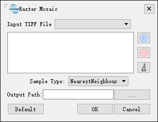
- Input Tiff File: Users can select multiple files (>1) to be processed from the drop-down list.
: Users can add multiple external images for image mosaic.
: Users can select a file in the list and click this button to remove the file from the list.
: Click this button to clear all images in the list.
- Sample Type: Users need to select the sampling type from the drop-down list.
- NearestNeighbour (default): Nearest neighbor, sampled from the nearest neighbor.
- Bilinear: Bilinear sampling (2 x 2 cores).
- Cubic: Cubic convolution approximation (4 x 4 kernels).
- CubicSpline: Cubic B-spline approximation (4×4 kernel).
- Lanczos: Lanczos Window Sine Interpolation (6×6 Cores). Lanczos can be used as a low pass filter or to smoothly interpolate the value of a digital signal between its samples.
- Average: Calculate the average of all non-value pixels.
- Mode: Select the most frequently occurring value for all sampling points.
- Output path: Path of the output folder. After the function is executed, a new file will be generated.