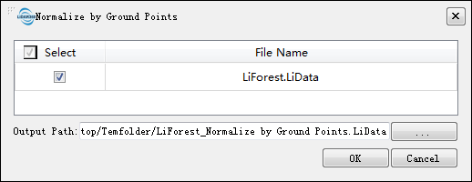
Normalize by Ground Points
Functional Overview
The normalization tool can remove the effects of topographic relief on the elevation value of point cloud data. This function requires that the input data has already been classified into ground points and non-ground points. The normalization process is performed by subtracting the terrain elevation (represented by the elevation of the closet ground point to each point) from each point's Z value. The output of this function is similar to Normalize by DEM.
Usage
Click Data Management > Point Cloud Tools > Normalize by Ground Points

Parameters Settings
- Input Data: The input file can be a single point cloud data file or multiple data files. File Format: *.LiData.
- Search Mode: 2D method is suitable for most terrains, while 3D method is suitable for cliff terrain and can solve the problem of incorrect vegetation height after normalization. However, steep slopes or other terrains are recommended to use 2D search.
- Add Z Value to Additional Attributes: Add the Z value of the current point cloud to the additional attribute table. If this option is not checked, then the normalized point cloud cannot be denormalized.
- Output path: Path of the output file. After the function being executed, the normalized new file will be generated. When entering more than one file, the path needs to be set as a folder.