Generating elevation annotations
Summary
Using point cloud and contour lines to generate elevation points for topographic mapping.Notes Elevation Points File.
Usage
Click Terrain > Generating elevation annotation.
Settings
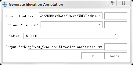
- Input Tiff File: Input DEM file format in LiData.
- Input Contour File (.shp): Input Contour file format in shp,The file needs to contain one or more contours.
- Radius (m)(default value is "15"): A Note Elevation Point is generated within a region with a defined radius.
Output path: The path of the generated contour lines file(s) to save.
Point Cloud: The input file is a single point cloud data file.
Contour File: Input contour file in SHP format, which should contain one or multiple contour lines.
Sampling Method: Includes Circle, grid, and diamond sampling methods.
- Sampling Distance: The distance between adjacent sampled annotation points.
- Conflicting Notes: Method for handling conflicting annotation points. Keep: retains originally sampled elevation annotation points; Modify: adjusts conflicting annotation point elevations based on adjacent contour lines; Delete: removes conflicting annotation points.
- Output Path: The output path for elevation annotation points (only valid when contour lines are in SHP format).