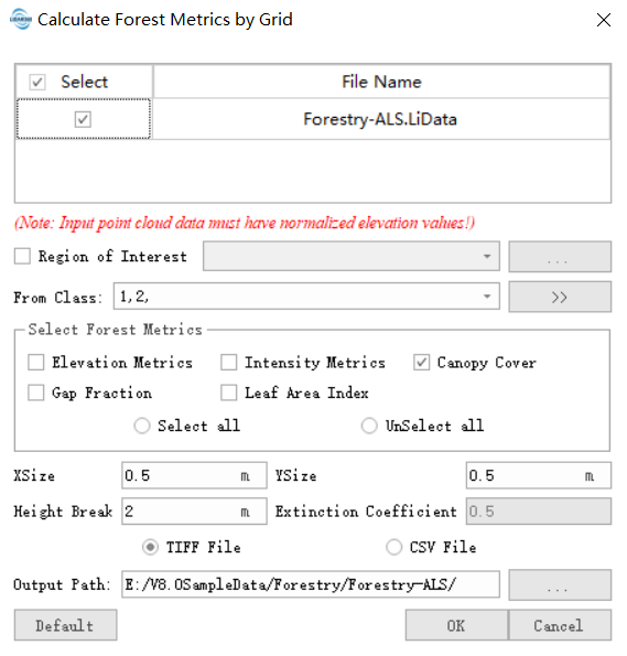
Calculate Forest Metrics by Grid
Functional Overview
Calculate the forest metrics based on the point cloud data in grids. Split the point cloud data with multiple grids, and then calculate the forest metrics in each grid. The forest metrics include elevation, intensity, canopy cover, Leaf Area Index and gap fraction. First, this function will divide the point cloud into different grids with a certain size in the horizontal direction. And then Calculate the forest metrics based on users selection, and, for each grid, generate a CSV file or TIFF file to store the result.
Usage
Click ALS Forest > Forest Metrics > Calculate Forest Metrics by Grid to generate the selected forest metrics.

Parameters Settings
- Region File (Optional): After inputting the area of interest, grids outside the interest area will not be output. For TIFF results, grids outside the interest area will be assigned a NODATA value (null value). As shown in the diagram below, if the black line represents the area of interest, the red grids will be assigned as NODATA, and the green grids will be retained, because the center of the red grid is outside the area of interest. The boundaries of all the green grids will be output as a vector file in the result.

- Input data: Ensure that each input point cloud data is normalized; the input file can be a single data file or a point cloud data set; the file(s) to be processed must be opened in the LiDAR360 software.
- XSize and YSize (meter) (default value is "15"): This value should be larger than the crown size of the trees. For the data acquired from most of the forest, this value should be larger than 15.
- Height Break (meter) (default value is "2"): The threshold to divide the data in vertical direction. The point cloud above this height will be used to calculate the forest metrics. The default value is 2m.
- Extinction Coefficient (default "0.5"): A mathematical expression of leaf probability distribution in three-dimensional space, which is related to vegetation type, leaf angle, and beam direction. According to the empirical formula, the user can determine the value of leaf angle distribution according to the actual situation of the forest. Studies have shown that the elliptic distribution of leaf angle, which has a leaf angle distribution value of 0.5, may be applicable to the actual situation.
- Output Path: Output path. After running, each input point cloud data file will generate a corresponding CSV file or a set of TIFF files, which can be used as independent variables in regression analysis.
- Default: Restore the setting parameters to the default values.
Note: Only when the point cloud data is loaded in the software can you use the Elevation Metrics function; otherwise, the message "There is no point cloud data meeting the conditions of calculation!" will pop up. If the maximum Z value of the point cloud is greater than 200 or the maximum Z minus the minimum Z is greater than 200, the data is considered to be unnormalized, and the software will pop up the prompt message shown in the figure below, click "YES", this type of data Still participating in the calculation, click "NO", this type of data will not participate in the calculation, and the user can re-select the data that meets the conditions.