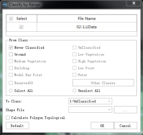
Classify by Range
Summary
Initial points within the polygon are classified into target categories.
For Polygonal objects in the vector data, if the calculation of topological relationship is not checked, the points of all initial categories in the polygon will be divided into the target category; if the calculation of topological relationship is checked, the points in the interval between the inner polygon and the outer polygon will be The points of the initial class are divided into the target class, and the points in the inner polygon remain unchanged.
For Multi-Polygonal object in the vector data, the points of the initial category in the interval between the inner polygon and the outer polygon are divided into the target category, and the points in the inner polygon remain unchanged.
Usage
Click Classify > Classify by Range.

Settings
- Input Data: The input file can be a single point cloud data or a point cloud dataset, which must be opened in the LiDAR360 software.
- From Class: Categories to be classified.
- To Class: Classification target category.
- Vector File: User can select the Vector File loaded into LiDAR360 software from the drop-down menu, or select
 button to load an external vector data file.
 - Whether to calculate the topological relationship of polygons: For the Polygonal object in the vector data, calculate the topological relationship between polygons. If checked, the topological relationship between polygons will be calculated; if not checked, all points in the Polygon will be generated into a new file.