DJI L1/L2 Reconstruction
Function Overview
The DJI L1/L2 reconstruction feature supports the processing of Zenmuse L1 and Zenmuse L2 data. It converts the raw LiDAR files from the L1 and L2 into various formats of 3D point cloud data (PNTS/LAS/PLY/PCD/S3MB). It supports point cloud classification, generates Digital Elevation Models (DEMs), and allows users to import the results into downstream analysis software for applications in surveying, power industry, etc.
Usage
Click Strip Alignment > DJI L1/L2 Reconstruction.

Parameter Settings
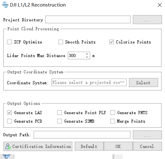
Project Directory: Users can click the button on the right to select the directory of the raw LiDAR data for L1 and L2.
Scene:
- Output Point Cloud: Users can select this option to output point cloud results.
- Refine calibrate: Users can select this option to perform refine calibrate.
Point Cloud Processing:
- ICP optimise: Users can select this option to optimise the LiDAR point cloud using the ICP (Iterative Closest Point) algorithm.
- Smooth point: Users can select this option to smooth the LiDAR point cloud.
- Colorize points: Users can select this option to color the LiDAR point cloud.
- LiDAR Point Max Distance: Set the maximum effective distance for the LiDAR point cloud. Points beyond this distance will be clipped.
Output Coordinate System: Users can select the coordinate system for the output results. If not specified, the algorithm will automatically determine it.
Output Format:
- LAS: Users can select this option to generate point cloud model results in LAS format.
- PLY: Users can select this option to generate point cloud model results in PLY format.
- PNTS: Users can select this option to generate point cloud LOD models in PNTS format, viewable with Terra software or Cesium web viewer.
- PCD: Users can select this option to generate point cloud model results in PCD format.
- S3MB: Users can select this option to generate point cloud model results in S3MB format, viewable with SuperMap software.
- Merge Point: Users can select this option to merge the point cloud into a single file.
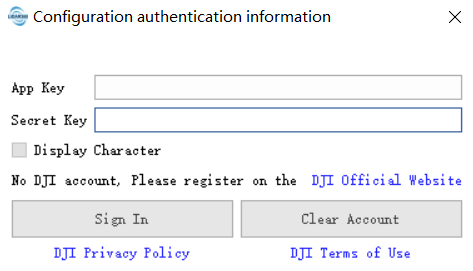
Configuration authentication information:

- App Key: Enter the App Key authorized by DJI Terra.
- Secret Key: Enter the Secret Key authorized by DJI Terra.
Output Path: The folder path where the generated and downloaded results will be saved during the execution of the function.