Change Detection
Functional Overview
Calculate the relative change in height between two point clouds and output it as a TIFF image and an HTML report. In the image, red represents an increase while green represents a decrease, with other areas displayed in grayscale according to their elevation values. The relative change in height between the two point clouds will be added as additional attributes to the corresponding LiData files (for example, the elevation change of a comparison point cloud relative to a reference point cloud will be written as an additional attribute to the comparison point cloud's LiData). This function can be used for disaster analysis, illegal construction comparison, earthwork volume change analysis, vegetation growth change analysis, etc.
Usage
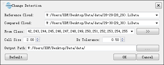
Click Terrain > Multi-period Analysis > Change Detection.

Parameters Settings
- Reference Cloud: Select the reference point cloud. The reference point cloud is used as a baseline for comparing against other clouds; its changes (currently only Z-values) are recorded as "DistanceReference" attribute and shown in green color on images.
- Compared Cloud: Select the comparison point cloud. Changes (currently only Z-values) of this compared with those of Reference Point Cloud are recorded as "DistanceCompare" attribute and shown in red color on images.
From Class: Starting class of points that participate in change detection. Each category from both sets of points will be compared separately.
Cell Size: Grid length when converting points into grids; smaller values result in more detailed comparisons but take longer time.
Dz Tolerance Min/Max: Only when changes fall within these limits would they be assigned distance values; otherwise, they are considered as no change and the corresponding distance value is 0.
- Output Path: Output path for intermediate results and HTML report.
- Default: Click this button to restore all parameters to their default values.
- Report Setting: After the function finishes running, a pie chart of change statistics will be generated as shown below.

Note: The LiData versions of both reference point cloud and comparison point cloud must be 2.0 or above. Lower version LiData can be converted to higher version using Convert LiData to LiData. Note: Additional attribute values can be displayed by right-clicking on them in the menu.