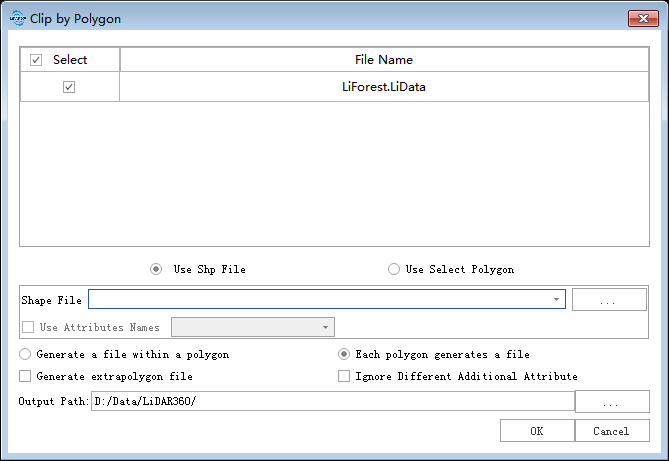
Clip by Polygon
Summary
Clip by polygon tool extracts the point cloud data within a user-defined polygon vector file, and the extracted points will be saved in one or several files.
Usage
Click Data Management > Clip > Clip by Polygon

Settings
- Input Data: Select one or more point cloud data files. File Format: *.LiData.
- Interactive Polygon: Click to start to create the polygon. Click in the viewer to select the nodes and double-click to end selecting. After this, the polygon will be added to the polygon list. Click
to delete the polygon in the list.
- Use Vector File: User can select the Vector File loaded into LiDAR360 software from the drop-down menu, or select
 button to load an external vector data file.
 - Using Shp File Attribute Naming: Available when Generate Multiple Files is selected and the vector data contains attribute tables. The user can select the corresponding attribute value as the file name. When the attribute value does not exist, the files are automatically named in numerical order.
- Ignore Different Additional Attributes: When inputs are several point cloud files, and this option is checked, only the same additional attributes of the point cloud files will be merged. If this option is unchecked, and there are some different attributes in the additional attribute tables, the mergence of different point cloud files cannot be done.
- Generate Single File: When users choose to export a single file, the point cloud will be clipped by all polygons in the vector data. All results will be saved in one file.
- Generate Multiple Files: When users choose to export single file, the point cloud will be clipped by all polygons in the vector data. The point cloud in each polygon unit will be saved as one file.
- Generate Extra Polygon File:When this option is checked, points outside the polygon will also be saved as a separate file.
- Calculate Polygon Topological:Calculate the topological relationships between polygons in the vector data. If this option is checked, the topological relationships between polygons will be calculated; if unchecked, all points within each polygon will be saved as a new file.
- Output Path: The result output folder path.