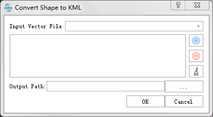
Convert Shape to KML
The data in shape format will be converted to KML format. KML format reference:https://wiki.openstreetmap.org/wiki/KML
Usage
Click Data Management > Conversion > Convert Shape to KML.

Parameters
- Input Shape File: Input the vector files that need to be converted.
- Projection Coordinate System: KML files contain geographical coordinates (latitude and longitude) for points, lines, and polygons. By selecting a projection coordinate system, you can convert the geographical coordinates in the KML file to projected coordinates. For information on choosing a coordinate system, refer to Define Projection. If no projection coordinate system is selected, the coordinates will be output as they are.
- Output Path: Choose the directory path for the output files, specifying where the KML files will be saved.