International Report
Summary
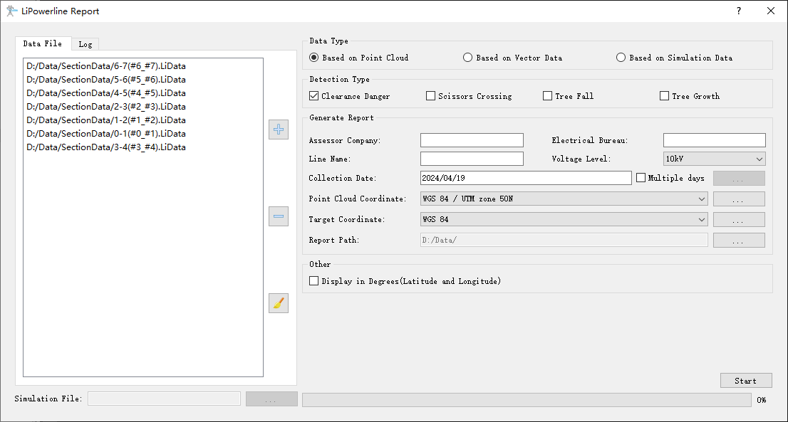
The international report is the general version report. It can generate the report based on different data type and detection type. The interface of "generate report" function is shown as follow. This function can process multiple data simultaneously. Click ![]() to add the data to be processed. Click
to add the data to be processed. Click ![]() to remove the selected data. Click
to remove the selected data. Click ![]() to clear the data list.
to clear the data list.

Settings
- Data Type: Select the data type to be processed. The data type includes point cloud based data, vector based data, and data based on working conditions simulation. The software can record the user's current settings and automatically restore the settings when opened again.
- Based on Point Cloud: Extract the powerline data from the original point cloud data.
- Based on Vector Data: Extract the powerline data from the vector file, and other classes objects from original point cloud data.
- Based on Simulation Data: Extract the powerline data from the simulation file, and other classes objects from original point cloud data.
- Detection Type: User can select multiple options. Set the detection type, and generate corresponding reports.
- Clearance Danger: Clear the clearance danger point detection result in the cache folder.
- Scissors Crossing: Clear the scissors crossing point detection result in the cache folder.
- Tree Fall: Clear the tree fall detection result in the cache folder.
- Tree Growth: Clear the tree growth detection result in the cache folder.
- Generate Report: Set the parameters for report generation.
- Assessor Company: The company which generates the report.
- Electrical Bureau: The name of power supply bureau or company.
- Line Name: Line name.
- Voltage Level: Cannot be changed by user.
- Collection Date: The date on which point cloud was collected.
- Point Cloud Coordinate: The coordinate system used in the point cloud data.
- Target Coordinate: The coordinate system used in the report.
- Report Path: The output path of the report.
- Other:
- Display in Degrees(Latitude and Longitude): The coordinates are displayed in longitude, latitude, or radians.
- Simulation File: If user choose to generate the report based on the simulated working conditions data, it is required to set the simulation file (*.LiSim file).
Note: Data type and detection type are combined to use. If user wants to generate the clearance danger and scissors crossing points report based on the point cloud data, they need to choose "Data Based on Point Cloud" in the data type, and "Clearance Danger" and "Scissors Crossing" in the detection type. Then set the other parameters, and Click "Start" to generate the report.