Clip by Circle
Brief
Clip by circle tool extracts the point cloud data within user-defined circle(s), and the extracted points can be saved in one or multiple files.
Usage
Click Data Management > Clip > Clip by Circle
Settings
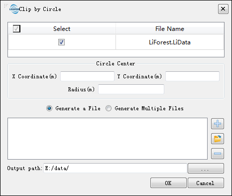
- Input Data: Input one or more point cloud data files. File Format: *.LiData.
- X Coordinate (m): Enter the X coordinate of the circle center.
- Y Coordinate (m): Enter the Y coordinate of the circle center.
- Radius (m): Enter the radius of the circle.
- Generate a File: Extract all the point cloud data within 2D circle(s) to one file.
- Generate Multiple Files: Extract the point cloud data within each circle and save them to one individual file. The file is named by its center and radius by default.
 : Click this button to add the coordinates and radius of a circle to the processing list. Perform the same operation to add multiple clipping circles.
 : Click this button to load external data files. The file format refers to the Clip Range File Format in the appendix.
 : Click this button to remove the selected row(s) in the processing list.
- Output path: The generated file will be saved in this output path.