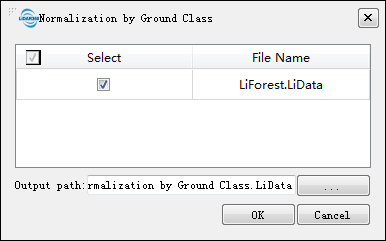
Normalization by Ground Class
Brief
The normalization tool can remove the effects of topographic relief on the elevation value of point cloud data. This function requires that the input data has already been classified into ground points and non-ground points. The normalization process is performed by subtracting the terrain elevation (represented by the elevation of the closet ground point to each point) from each point's Z value. The output of this function is similar to Normalization.
Usage
Click Data Management > Point Cloud Tools > Normalization by Ground Class

Settings
- Input Data: The input file can be a single point cloud data file or multiple data files. File Format: *.LiData.
- Output path: Path of the output file. After the algorithm being executed, the normalized new file will be generated. When entering more than one file, the path needs to be set as a folder.