Multi Pick Point
Brief: This tool is applicable to point cloud data, raster data and model data. For point cloud data, the attributes that can be queried contain position, intensity, return number, classification and GPS time. For raster data, the attributes that can be queried contain position, stretched RGB value and pixel value. Different from the pick point tool, this tool allows querying multiple points at the same time, and the selection set can be exported in *.txt format.
Usage
Click Point Cloud > Measurement > Points
Steps
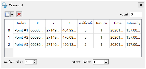
- Left-click the points in the scene and the selection results are marked by labels. At the same time, a table that contains the attributes of the selection points will pop up, shown as follows.
The attributes of point cloud data shown in the table contain index, position (XYZ), classification, return number, GPS time and intensity. The attributes of raster data shown in the table contain index, position (XY) and band value. The total number of the points is updated real-time above the table.

- The "marker size" is used to set the point size of the marker in the scene. The "start index" is used to set the start index of the selected points.
- Double-click a row of the table, the scene will go to the position of the corresponding point automatically.
- Select a row of the table by left-clicking and click the button
 to delete the point.
 - The selection set can be exported as *.txt format. Click the drop-down menu
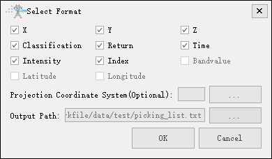
 to pop up "Select Format" dialog, as shown below. If the selected points belong to raster data, then the menu "Save 2D points" is available. If the selected points belong to 3D data, then the menu "Save 3D points" is available. If the selected points contain 2D data and 3D data, then the menu "Save all points" is available.
- Click
 to pop up the export dialog. Input the output path, and check the attributes that need to be exported. Click "OK" to complete the export. Click "Cancel" to cancel the export.
 - If the selected points have not been saved before quitting this tool, a message box will pop up as follows. Click "Save" to save the points. Click "Discard" to cancel the selections.

Settings
- X: X component of the coordinate.
- Y: Y component of the coordinate.
- Z: Z component of the coordinate.
- Classification: The class attribute of point cloud data.
- Return: The return number attribute of point cloud data.
- Time: The GPS time attribute of point cloud data.
- Intensity: The intensity attribute of point cloud data.
- Index: The index of select point.
- BandValue: The band value of raster data.
- Output Path: The path of the output file.
Note: This tool only works with point cloud data, raster data and model data. If the center of rotation needs to be changed, hold down the the Ctrl key and select the center of rotation with the left mouse button. This tool is available in the profile window too.