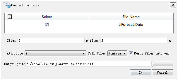
Convert to Raster
Brief
The Convert to Raster tool can convert LiData point cloud data to raster images according to the Attribute of the points in Cell Value method.
Usage
Click Data Management > Conversion > Convert to Raster

Settings
- Input Data: The input file can be a single point cloud data file or multiple data files. File Format: *.LiData.
- XSize (m, default value is "2"): The X pixel resolution of the output raster.
- YSize (m, default value is "2"): The Y pixel resolution of the output raster.
- Attribute (default is "Z"): Select the point attribute used to calculate the raster cell value.
- Z (default): Generate the raster data using the Z value of the point cloud data.
- Intensity: Generate raster data using the intensity values of the point cloud data.
- Scan angle: Generate raster data using the scan angle of point cloud data.
- Return number: Generate raster data using the return number of the point cloud data.
- Number of returns of given pulse: Raster data is generated using the number of returns of given pulse of the point cloud data.
- Cell value: Choose how to fill raster pixel values.
- Minimum (default): Use the smallest attribute value as the value of a raster cell.
- Average: Use the average of attribute values of all points within a raster cell as its value.
- Maximum: Use the largest attribute value as the value of a raster cell.
- Merge files into one: Users can set merging all raster into one data file. If not checked, each point cloud data will be generated into a separate raster file.
- Output path: Path of output folder. After the algorithm is executed, the converted new file is generated.