Adjust Elevation
Brief
The elevation of raw laser data is normally represented by ellipsoidal height. Normally these values need to be transformed to values in regional height system or local height system. For large area, the adjustment of elevation can not be defined as a mathematical formula. Hence, the model of elevation adjustment is required to be defined. The algorithm is to build triangular network model using known control point data as well as to interpolate and correct local points using height anomaly between different height systems. Adjusted elevation result can be checked according to the Control Point Report.
It is recommended to use control point data containing entire project region to adjust model in order to provide more accurate elevation information to the project border.
Usage
Click Strip Alignment > Adjust Elevation

Setting
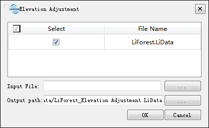
- Input Data: Input files can be single point cloud file or point cloud data set.
- Input File: Users need to input adjustment model file of control points. This file data can be generated by tool of Control Point Report.
- Output path: Output adjusted point cloud data.