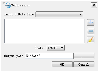
Subdivision
Brief
Subdivision tool can divide a point cloud to a series of frames based on the user defined scales. Currently, LiPowerline supports four subdivision scales: a scale of 1:5000 (taken to 1 km), 1:2000 (taken to 0.1 km), 1:1000 (taken to 0.1 km), and 1:500 (taken to 0.01km). Moreover, only subdivision in rectangular is supported currently. The frame ID will be named by the coordinate number, which is composed of the southwest corner of the frame (Y coordinate + X coordinate). After the operation is completed, a vector file will be generated in shp format recording each subdivided frame.
Usage
Click Data Management > Point Cloud Tools > Subdivision

Settings
- Input LiData File: Input the point cloud data to be subdivided. If the point cloud data is already open in the software, click the drop-down button to select the data; or you can click
 to open external point cloud data. Click
  to remove the selected data. Click
  to clear the image data list. File format: *.LiData.
 - Scale: User-defined scale. LiPowerline has four scales: 1:500, 1:1000, 1:2000, 1:5000.
- Output path: Path of the output folder. After the algorithm is executed, a new shp file will be generated.