Extract by Elevation
Brief
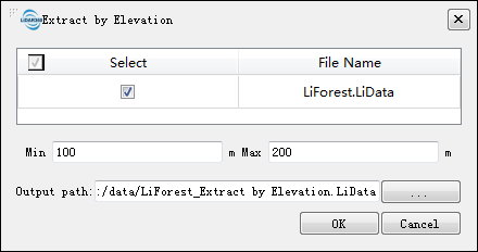
Extract by Elevation tool can extract the point cloud data in the user-defined elevation range to a file. This function supports multiple file operations.
Usage
Click Data Management > Extract > Extract by Elevation S
Settings
- Input Data: Input one or more point cloud data files. File Format: *.LiData.
- Min (m, default value is "100"): Users need to enter the minimum elevation value of the point cloud data to be extracted.
- Max (m, default value is "200"): Users need to enter the maximum elevation value of the point cloud data to be extracted.
- Output path: Path of the output folder. After the algorithm being executed, the extracted new file(s) will be generated.