Define Projection
Brief
Define projection information for point cloud data, including geographic coordinates (usually latitude and longitude coordinates) and projection coordinates (plane coordinates converted by projection).
Usage
Click Data Management > Point Cloud Tools > Define Projection

Settings
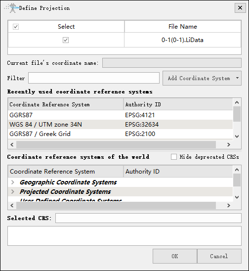
- Input Data: The input file can be a single point cloud data file or multiple data files. File format: *.LiData.
- Filter: Users need to enter the customized coordinate system. By entering the coordinate system keywords, the corresponding coordinate system can be filtered from the Coordinate reference systems of the world table (for example: to set the point cloud coordinate system to WGS 84 / UTM Zone 49N, users can enter UTM 49N in the filter for fast screening, or enter its EPSG number: 32649 for quick search.) Users can also import external coordinate system settings by clicking the Add Coordinate System button.
- Add Coordinate System: Users can add external coordinate system settings or customize coordinate system settings. LiPowerline software provides four ways to add external coordinate system:
- Hide deprecated CRSs: Hide deprecated coordinate systems.
Import from WKT
WKT format can refer to the following way:
    GEOGCS[
        "GCS_Beijing_1954"
      ,DATUM["D_Beijing_1954",SPHEROID["Krasovsky_1940",6378245.0,298.3]]
        ,PRIMEM["Greenwich",0.0]
        ,UNIT["Degree",0.0174532925199433]
        ,AUTHORITY["EPSG",4214]
    ]


    PROJCS[
        "MyProjCS"
        ,GEOGCS["WGS84",DATUM["WGS_1984",SPHEROID["WGS84",6378137,298.257223563,AUTHORITY["EPSG","7030"]],TOWGS84[0,0,0,0,0,0,0],AUTHORITY["EPSG","6326"]]
        ,PRIMEM["Greenwich",0,AUTHORITY["EPSG","8901"]]
        ,UNIT["degree",0.0174532925199433,AUTHORITY["EPSG","9108"]]
        ,AUTHORITY["EPSG","4326"]]
        ,PROJECTION["Transverse_Mercator"]
        ,PARAMETER["latitude_of_origin",0]
        ,PARAMETER["central_meridian",-81],PARAMETER["scale_factor",0.9996]
        ,PARAMETER["false_easting",500000]
        ,PARAMETER["false_northing",0]
        ,UNIT["Meter",1]
    ]
Import from PRJ
PRJ format can refer to the following way:
+proj=longlat +ellps=aust_SA +towgs84=-117.808,-51.536,137.784,0.303,0.446,0.234,-0.29 +no_defs
Add Geographic Coordinate System

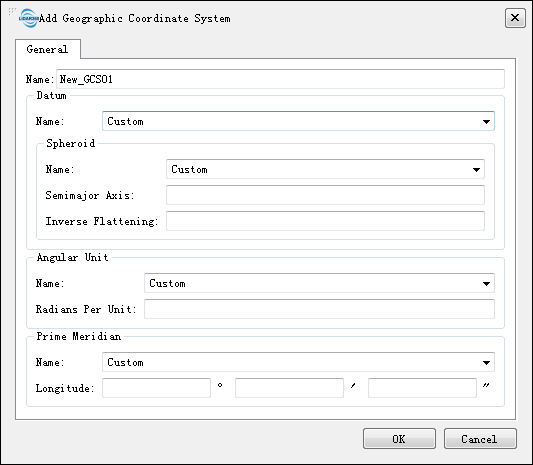
- Name: Users can customize a geographic coordinate system name.
- Datum:
- Name: Users can customize a datum name or select a known datum from the drop-down list.
- Spheroid: If a user selects the datum from the drop-down list, the ellipsoid parameter does not require user to enter.
- Name: The name of the spheroid.
- Semimajor Axis: Spheroid's major semi axis.
- Inverse Flattening: Inverse flattening of the spheroid.
- Angular Unit:
- Name: Users can customize the angle unit name, or select the angle unit name from the drop-down list.
- Radians Per Unit: Define the unit of arc in the geographic coordinate system.
- Prime Meridian:
- Name: Users can customize the name of the central meridian, or select the name of the central meridian from the drop-down list.
- Longitude: Input the central meridian longitude.
Add Projected Coordinate System

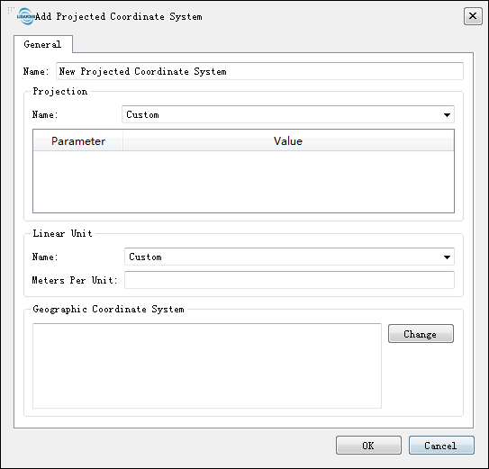
- Name: Users can customize the name of a projection coordinate system.
- Projection:
- Name: Users can customize a projection name or select a known projection from the drop-down list. It should be noted that user-defined projections can be modified from a projection template selected from the drop-down list. Linear units:
- Linear Unit:
- Name: Users can customize the linear unit name or select the linear unit name from the drop-down list.
- Meters per Unit: Input meters per unit.
- Geographic Coordinate System: Users can paste the geographic coordinate system parameters into the text box, or click Change.
Change
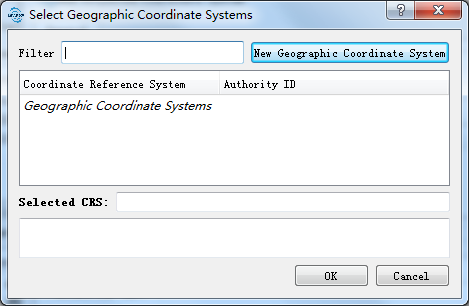
When the user clicks on the Modify button, the following dialog box will pop up for modifying the geographic coordinate system.

The user can filter out the needed coordinate system through the filter operation, or can also add the geographic coordinate system through the New Geographic Coordinate System and the setting method is the same as Add Geographic Coordinate System.