Clip/Classify
Summary
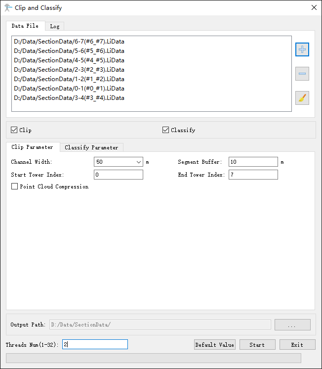
Clipping and classifying the point cloud data into segments. The classification process will classify the tower, conductor, shield line, insulator, drainage thread, scissors crossing line, ground, vegetation, buildings, road, and water in the point cloud. This function can process multiple data simultaneously. Click ![]() to add the data to be processed. Click
to add the data to be processed. Click ![]() to remove the selected data. Click
to remove the selected data. Click ![]() to clear the data list.
to clear the data list.
Usage
Click Clip/Classify > Clip and Classify.


Settings
- Output Path: Set the output path.
- Clip (Checked by default): Clip the data into segments. If this option is unchecked, the data will not be clipped.
- Channel Width (meter) (default value is "60"): Width extending along both sides of the power line. The software can record the user's current settings and automatically restore the settings when opened again.
- Segment Buffer (meter) (default value is "10"): Extension distance at both ends of the transmission tower.
- Start Tower Index: Towers with index numbers smaller than this value do not participate in gear shifting. The default value is the minimum Index in the tower file.
- End Tower Index: Towers with index numbers greater than this value do not participate in gear shifting. The default value is the maximum Index in the tower file.
- Point Cloud Compression (Unchecked by default): Resampling the processed data.
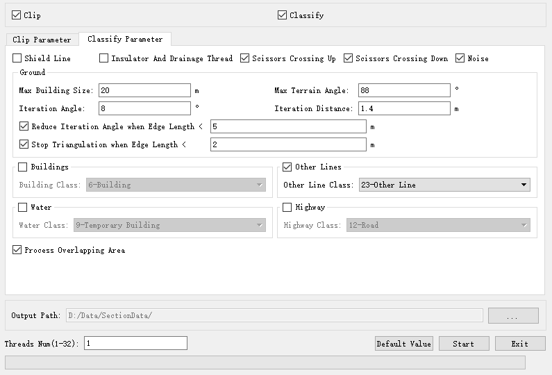
- Classify (Checked by default): Using deep learning classification strategies to classify categories such as towers, conductors, shield lines, insulators, drainage thread, scissors crossing up, scissors crossing down, other lines, buildings, water, highway and noise.
- Shield Line: Classify shield lines.
- Insulator And Drainage Thread: Classify insulators and drainage threads, with this option available for voltage levels of 35kV and above.
- Scissors Crossing Up: Classify scissors crossing up.
- Scissors Crossing Down: Classify scissors crossing down.
- Noise: Classify noises.
- Ground Points: Please refer to the classify ground tool for details.
- Buildings: Classify building points.
- Other Lines: Classify parallel lines.
- Water: Classify water points.
- Highway: Classify road points.
- Process Overlapping Area(Checked by default): Process the overlapping areas between segments in the section data to ensure consistent point cloud categories; If not checked, the point cloud in the overlapping area of adjacent segment data may flicker during browsing due to inconsistent categories.
- Threads Number (default value is "6"): Set the number of thread (1 to 32) to run this function. The software can record the currently setting and when the user open this function again, the setting will be kept.
- Default Value: Restore the default parameter settings.
Note: The segmented data will be stored in the output path folder. The name of the file will be (Smaller Tower Index_Larger Tower Index). In order not to impact the following steps, it is highly recommended not to change the file name. After the automatic classification, user need to check the accuracy of the result and manually modify it in the Profile Tools.